Ortelius, Abraham
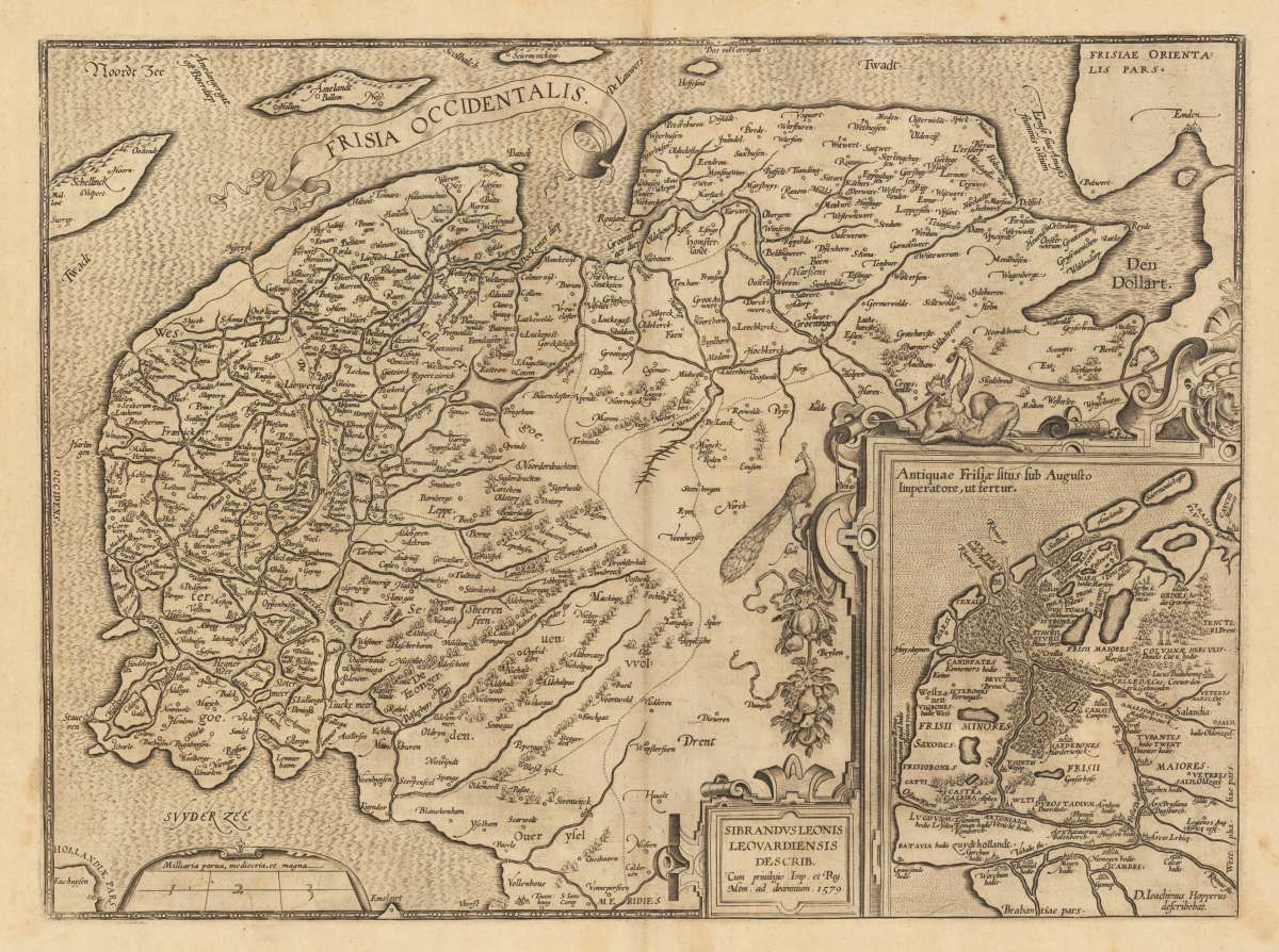
Frisia Occidentalis. Sibrandus Leonis Leovardiensis Describ. Cum privilegio Imp. et Reg. Mtm. ad. decenninium. 1579.
Frisia Occidentalis. Sibrandus Leonis Leovardiensis Describ. Cum privilegio Imp. et Reg. Mtm. ad. decenninium. 1579. - Abraham Ortelius ∑ Hand-Colored Origin...
Eigenschaften
- Published: Antwerp
- Published date: 1612
- Issue date: 1612
- Technique: Copper engraving
- Type: map
- Category: Friesland
- Size: 36.8 x 49,8 cm (14.5 x 19,5 inches).
- Bibliography: Broe. 81
- Stock number: 33372
- Condition: A minor printer's crease on the right side of the double page, slightly visible. Overall in excellent condition.
Article description
Article description
Hand-Colored Original Copperplate Engraving by Abraham Ortelius, depicting Frisia Occidentalis. Sibrandus Leonis Leovardiensis Describ. Cum privilegio Imp. et Reg. Mtm. ad. decenninium. 1579.. Published Antwerp, Juan Baptist Vrients, 1612. Sheet: 36.8 x 49,8 cm (14.5 x 19,5 inches).. A fine and original hand-colored example of Ortelius's celebrated cartographic work, documenting this region of Germany with the precision and decorative artistry characteristic of the 16100s. Abraham Ortelius (1527-1598) was a Flemish cartographer and geographer from Antwerp, widely regarded as the creator of the first modern atlas. His landmark publication Theatrum Orbis Terrarum (1570) set the standard for atlas-making for the next century, presenting uniform copper-engraved maps with scholarly commentary. By Ortelius's death, the Theatrum had appeared in 25 editions in seven languages. In 1575, King Philip II of Spain appointed him Royal Geographer. His maps, engraved with extraordinary precision, are among the most sought-after in antique cartography, held in collections including the Plantin-Moretus Museum in Antwerp, the Library of Congress, and the British Library. This original copperplate engraving, with original hand coloring depicts the region of Frisia Occidentalis. Sibrandus Leonis Leovardiensis Describ. Cum privilegio Imp. et Reg. Mtm. ad. decenninium. 1579., published in Antwerp, Juan Baptist Vrients, 1612. An inset map is included, providing additional geographic context. The map records the political and geographic boundaries of the region as understood in 1612, offering a fascinating window into the history of German territorial organization. Sheet measures 36.8 x 49,8 cm (14.5 x 19,5 inches).. In good condition overall, with minor signs of age appropriate for a 17th-century engraving. Ready to frame.Frisia Occidentalis. Sibrandus Leonis Leovardiensis Describ. Cum privilegio Imp. et Reg. Mtm. ad. decenninium. 1579. - Abraham Ortelius ∑ Hand-Colored Origin...
Broe. 81
You might also be interested in the following products
 Niedersachsen
 Hand-Colored Original Copperplate Engraving by Gerard Mercator, depicting Niedersachsen. Published Amsterdam, Jodocus...
€300.00
 Episcopatuum...
 Hand-Colored Original Copperplate Engraving by Matthäus Seutter, depicting Episcopatuum Monasteriensis Et...
€495.00
 Saxoniae...
 Hand-Colored Original Copperplate Engraving by Matthäus Seutter, depicting Saxoniae Inferioris Circulus juxta...
€300.00
 Ducatus...
 Hand-Colored Original Copperplate Engraving by Matthäus Seutter, depicting Ducatus Luneburgicus cum Comitatu...
€275.00
Recently viewed products