Seutter, Matthäus
Trevirensis Archi-Episcopatus et Electoratus juxta omnes suas Praefecturas cum confini tractu Eyfaliae recentissime...
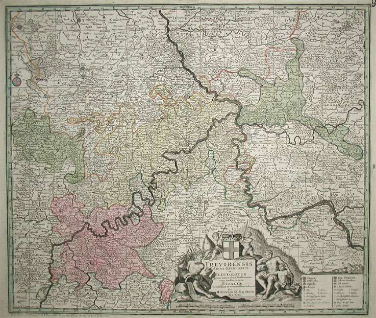
Trevirensis Archi-Episcopatus et Electoratus juxta omnes suas Praefecturas cum confini tractu Eyfaliae recentissime et accuratissime delineat. Per M. Seutter...
Eigenschaften
- Published: M. Seutter , Augsburg
- Published date: 1720
- Technique: Copper engraving / Original color.
- Type: Antique Map, map
- Category: Rheinland-Pfalz
- Issue date: 1720-30
- Size: 497 by 582mm (19 by 23 inches).
- Stock number: 17353
- Condition: A strong impression in excellent condition and decorative hand color. 497 by 582mm (19 by 23 inches).
Article description
Article description
Hand-Colored Original Copperplate Engraving by Matthäus Seutter, depicting Trevirensis Archi-Episcopatus et Electoratus juxta omnes suas Praefecturas cum confini tractu Eyfaliae recentissime et accuratissime delineat. Per M. Seutter S.C. Maj. Geogr. Aug. Vind.. Published Augsburg, M. Seutter, 1720. Sheet: 497 by 582mm (19 by 23 inches).. A fine and original hand-colored example of Seutter's celebrated cartographic work, documenting this region of Germany with the precision and decorative artistry characteristic of the 17200s. Matthaus Seutter (1678-1757) was one of the most prolific German cartographers of the 18th century, based in Augsburg. He trained as an engraver under Johann Baptist Homann in Nuremberg before establishing his own publishing firm in Augsburg around 1717. His skill and output were so impressive that Holy Roman Emperor Charles VI appointed him Imperial Geographer in 1732 -- a title he shared with his former master Homann. Seutter produced over 500 maps during his career, known for their richly detailed cartouches, decorative borders, and brilliant hand coloring. His work is held in collections at the Augsburg City Library, the Staatsbibliothek Berlin, and major museums across Europe. This original copperplate engraving, with original hand coloring depicts the region of Trevirensis Archi-Episcopatus et Electoratus juxta omnes suas Praefecturas cum confini tractu Eyfaliae recentissime et accuratissime delineat. Per M. Seutter S.C. Maj. Geogr. Aug. Vind., published in Augsburg, M. Seutter, 1720-30. The map features a decorative Baroque cartouche containing the title inscription. A distance scale is incorporated within the cartouche or alongside it. The cartouche is elaborated with allegorical or figural ornamentation. The map records the political and geographic boundaries of the region as understood in 1720-30, offering a fascinating window into the history of German territorial organization. Sheet measures 497 by 582mm (19 by 23 inches).. In good condition overall, with minor signs of age appropriate for a 18th-century engraving. Ready to frame.Trevirensis Archi-Episcopatus et Electoratus juxta omnes suas Praefecturas cum confini tractu Eyfaliae recentissime et accuratissime delineat. Per M. Seutter...
You might also be interested in the following products
 Palatinatus Rheni
 Original Copperplate Engraving by Gerard Mercator, depicting Palatinatus Rheni. Published Amsterdam, I.E....
€145.00
 Mosellae...
 Hand-Colored Original Copperplate Engraving by Johann Baptist Homann, depicting Mosellae Fluminis. Tabula specialis...
€290.00
 Theatrum Belli...
 Hand-Colored Original Copperplate Engraving by Baptist Homann, depicting Theatrum Belli Rhenani Auspicatis Militiae...
€295.00
 S.R.I. Circulus...
 Hand-Colored Original Copperplate Engraving by Johann Baptist Homann, depicting S.R.I. Circulus Rhenanus Inferior...
€245.00
Recently viewed products