Homann, Johann Baptist
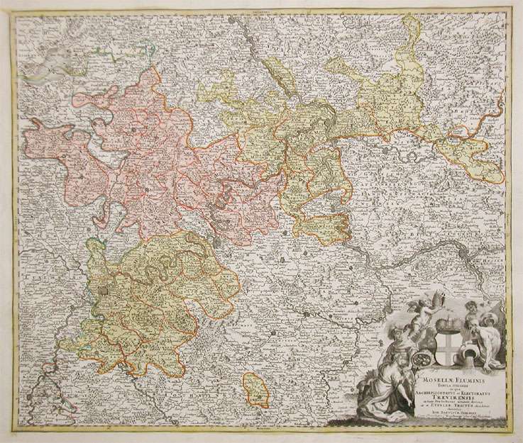
Mosellae Fluminis. Tabula specialis in qua Archiepiscopatus et Electoratur Trevirensis in suas Praefecturas accurate...
Mosellae Fluminis. Tabula specialis in qua Archiepiscopatus et Electoratur Trevirensis in suas Praefecturas accurate divisus ut et Eyfaliae Tractus ostenditu...
Eigenschaften
- Published: Homann , Nürnberg
- Published date: 1720
- Technique: Copper engraving / Original color.
- Type: Antique Map, map
- Category: Rheinland-Pfalz
- Issue date: 1720-30
- Size: 486 by 571mm (19 by 22 inches).
- Stock number: 17354
- Condition: A strong impression in excellent condition. Published plano without a centrefold. 486 by 571mm (19 by 22 inches).
Article description
Article description
Hand-Colored Original Copperplate Engraving by Johann Baptist Homann, depicting Mosellae Fluminis. Tabula specialis in qua Archiepiscopatus et Electoratur Trevirensis in suas Praefecturas accurate divisus ut et Eyfaliae Tractus ostenditur Sumtibus Ioh. Baptiste Homanni Cum Privilegio (Norimbergae) Sac. Caes. Majesttatis.. Published Nürnberg, Homann, 1720. Sheet: 486 by 571mm (19 by 22 inches).. A fine and original hand-colored example of Homann's celebrated cartographic work, documenting this region of Germany with the precision and decorative artistry characteristic of the 17200s. Johann Baptist Homann (1664-1724) was the foremost map publisher of 18th-century Germany. Born in Bavaria, he founded his cartographic publishing house in Nuremberg in 1702 and within a decade had become the dominant force in German-language cartography. In 1715, Holy Roman Emperor Charles VI appointed him Imperial Cartographer -- a prestigious title that gave Homann access to the most current geographic data and exclusive publishing privileges. His maps are celebrated for their bold copper engraving, elaborate Baroque cartouches, and vivid original hand coloring. Following Homann's death in 1724, the firm continued under the imprint 'Homann Heirs' (Homannsche Erben). His maps are held in major collections worldwide, including the Library of Congress, the British Library, and the Bayerische Staatsbibliothek. This original copperplate engraving, with original hand coloring depicts the region of Mosellae Fluminis. Tabula specialis in qua Archiepiscopatus et Electoratur Trevirensis in suas Praefecturas accurate divisus ut et Eyfaliae Tractus ostenditur Sumtibus Ioh. Baptiste Homanni Cum Privilegio (Norimbergae) Sac. Caes. Majesttatis., published in Nürnberg, Homann, 1720-30. The map features a decorative Baroque cartouche containing the title inscription. The cartouche is elaborated with allegorical or figural ornamentation. The map records the political and geographic boundaries of the region as understood in 1720-30, offering a fascinating window into the history of German territorial organization. Sheet measures 486 by 571mm (19 by 22 inches).. In good condition overall, with minor signs of age appropriate for a 18th-century engraving. Ready to frame.Mosellae Fluminis. Tabula specialis in qua Archiepiscopatus et Electoratur Trevirensis in suas Praefecturas accurate divisus ut et Eyfaliae Tractus ostenditu...
You might also be interested in the following products
 Palatinatus Rheni
 Original Copperplate Engraving by Gerard Mercator, depicting Palatinatus Rheni. Published Amsterdam, I.E....
€145.00
 Trevirensis...
 Hand-Colored Original Copperplate Engraving by Matthäus Seutter, depicting Trevirensis Archi-Episcopatus et...
€345.00
 Theatrum Belli...
 Hand-Colored Original Copperplate Engraving by Baptist Homann, depicting Theatrum Belli Rhenani Auspicatis Militiae...
€295.00
 S.R.I. Circulus...
 Hand-Colored Original Copperplate Engraving by Johann Baptist Homann, depicting S.R.I. Circulus Rhenanus Inferior...
€245.00
Recently viewed products