Fer, de Nicolaus.
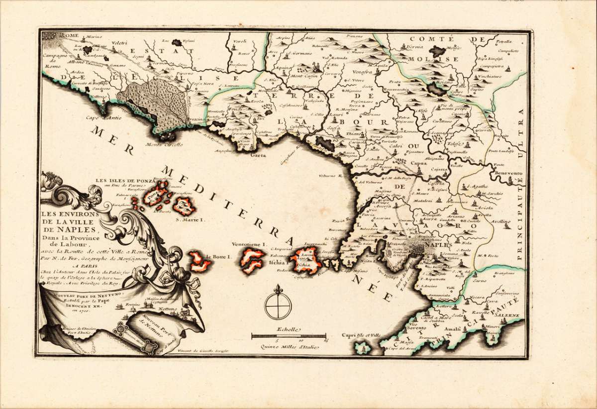
Les Environs De la Ville De Naples Dans la Province de Labour, avec la Routte de cette Ville a Rome Par N. de Fer...
Fer, de – Kingdom of Naples · Copper Engraving, Hand Colored · Introduction à la Géographie, Paris · 1700
Eigenschaften
- Published: N. de Fer , Paris
- Published date: 1700
- Technique: Copper engraving / Original color.
- Type: Antique Map, map
- Issue date: 1700-05
- Category: Southern Italy with Naples
- Size: 233 by 343mm (9 by 13 inches).
- Stock number: 15700
- Condition: Full margins as published. In excellent condition. 233 by 343mm (9 by 13 inches).
Article description
Article description
Original antique hand-colored copper engraving, published 1700. Depicting Kingdom of Naples, this map is a fine example of 0s European cartography. Image: 233 by 343mm (9 by 13 inches). An attractive and historically significant 18th-century map for the discerning collector. Nicolas de Fer (1646–1720) was a prominent French cartographer, engraver, and publisher based in Paris. After inheriting his father's mapmaking business, de Fer built it into one of the most productive cartographic firms in France, eventually becoming Geographer to King Louis XIV of France and King Philip V of Spain. His output was prolific—more than 600 sheet maps, town plans, and atlases—covering Europe, the Americas, and beyond. De Fer's maps are known for their decorative cartouches, attractive hand coloring, and commercial appeal, though they were sometimes criticized for prioritizing artistry over accuracy. His maps are particularly associated with the campaigns of the War of the Spanish Succession and are sought by collectors for their decorative quality. This hand-colored copper engraving map of Kingdom of Naples, published 1700, exemplifies the cartographic tradition of 1700s Europe. The map is engraved with careful attention to topographic detail, depicting towns, rivers, mountain ranges, and political boundaries with the precision expected of the finest cartographic productions of the period. The hand coloring highlights the geographic features and political divisions of Kingdom of Naples, making this an attractive piece for both the collector and the scholar. A fine example from Introduction à la Géographie, Paris, sought after by collectors of antique maps of Italy, antique maps of Kingdom of Naples, and antique hand-colored copper engravings for sale. In very good condition. Light age-toning to the sheet, as expected for a 18th-century map.Fer, de – Kingdom of Naples · Copper Engraving, Hand Colored · Introduction à la Géographie, Paris · 1700
You might also be interested in the following products
 Pedemontanae...
 Original antique copper engraving, uncolored, from the 'Theatrum Orbis Terrarum' by Abraham Ortelius, the...
€650.00
 Naples & Sicily
 Original antique lithograph, published 1852. Depicting Kingdom of Naples, this map is a fine example of 0s European...
€145.00
 Milane States
 Original antique hand-colored lithograph, published 1852. Depicting Milan & Lombardy, this map is a fine example...
€140.00
 Le Royaume de...
 Original antique hand-colored copper engraving, published 1705. Depicting Kingdom of Naples, this map is a fine...
€240.00
Recently viewed products