Ortelius, Abraham
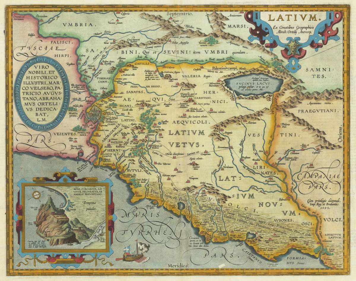
Latium. Ex Conatibus Geographicis Abrah. Ortelij Antverp.
Ortelius, Abraham – Rome & Latium · Copper Engraving · Theatrum Orbis Terrarum, Antwerp · 1612
Eigenschaften
- Published: Antwerp
- Published date: 1612
- Type: Antique Map, map
- Issue date: 1612
- Technique: Copper engraving / later hand colored.
- Category: Italy
- Size: 356 by 453mm (14 by 17 inches).
- Bibliography: Koe. Ort. 46; Broe: 209 state 2/2;
- Stock number: 30976
- Condition: In excellent condition.
Article description
Article description
Original antique copper engraving, from the 'Theatrum Orbis Terrarum' by Abraham Ortelius, the world's first modern atlas, published in Antwerp, 1612. Depicting Rome & Latium, this map is a fine example of 1610s European cartography. Image: 356 by 453mm (14 by 17 inches). An attractive and historically significant 17th-century map for the discerning collector. Abraham Ortelius (1527–1598) was a Flemish cartographer and geographer, born in Antwerp. He is widely regarded as the creator of the first modern atlas, the 'Theatrum Orbis Terrarum' (Theatre of the World), first published in 1570 by Gilles Coppens de Diest in Antwerp. Considered the world's first true atlas, it established the modern format of uniform, standardized maps bound together in a single volume. Appointed Geographer to King Philip II of Spain in 1575, Ortelius was one of the most influential figures in the history of cartography. His maps are held in the collections of the British Library, the Library of Congress, and major European institutions. The 'Theatrum' went through more than 30 editions and was translated into multiple languages, making Ortelius's maps among the most sought-after in the world of antique cartography. The map is ornated with three cartouches, in the upper left corner the title cartouche, on the upper right side we find an oval text cartouche and in the lower left corner an inset. The "privilegium" is written on the lower right side. Villages and towns are shown as miniature views. Moreover the map is ornated with a ship. A fine example from Theatrum Orbis Terrarum, Antwerp, sought after by collectors of antique maps of Italy, antique maps of Rome, and antique copper engravings for sale. In good condition consistent with age. Light age-toning to the sheet, as expected for a 17th-century engraving. Centerfold as published.Ortelius, Abraham – Rome & Latium · Copper Engraving · Theatrum Orbis Terrarum, Antwerp · 1612
Koe. Ort. 46; Broe: 209 state 2/2;
You might also be interested in the following products
 Moluccae Insulae...
 Original antique copper engraving, hand colored in outline and wash when published. A highly decorative map of the...
€550.00
 Pascaert van...
 Original antique copper engraving, uncolored as published. Detailed chart of the Northeastern part of Canada,...
€1,750.00
 Pascaarte vande...
 Copper Engraving, uncolored by van Keulen, Joan, published 1684-1704 by Johannes van Keulen, Amsterdam. Image size:...
€1,100.00
 Pedemontanae...
 Original antique copper engraving, uncolored, from the 'Theatrum Orbis Terrarum' by Abraham Ortelius, the...
€650.00
Recently viewed products