De Hooghe Romeyn
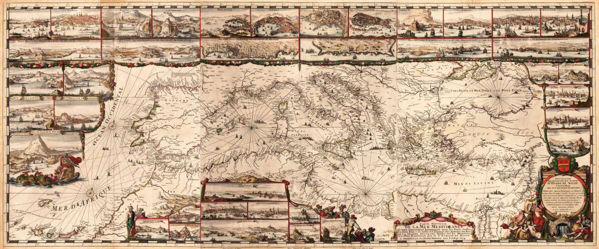
Carte Nouvelle de la Mer Mediterranee où sont Exactement Remarques tous les Ports, Golfes, Rochers, Bancs de Sable...
- Published: Amsterdam
- Published date: 1694
- Technique: Copper engraving / Original color
- Type: map
- Issue date: 1694
- Category: Romain De Hooghe's important chart of the Mediterranean Sea
- Size: 585 by 1390mm (23 by 54¾ inches).
- Bibliography: Koeman Mortier 5 & Vol IV p.424.
- Stock number: 29494
- Condition: Old colored example mounted on thin linen. Delicate heightened in gold. Overall in excellent condition.
Article description
Original copper engraving, hand colored in outline and partial heightened in gold in the period, when published in 1694. Oversize map printed from 3 plates, total dimensions ca. 58,5 x 139 cm. Beautiful hand colored overall. This is the most decorative and famous antique map of the Mediterranean Sea published in the 17th century. It was published 1694 in the large sea atlas 'Neptune François' by Pierre Mortier. The atlas was titled 'Cartes marines a l'Usage des Armées du Roy de la Grande Bretagne'. This sea atlas can be regarded as the most spectacular sea atlas published in that period. It incorporated this oversize fine highly decorative engraved map of the entire Mediterranean Sea. This monumental sea chart of the Mediterranean Sea from the Atlantic towards Asia Minor is surrounded by 38 inset views of harbors or ports of Mediterranean coastal cities or towns. Among these panoramic views of ports we do find among others the following cities: Marseilles, Genoa, Naples, Venice, strait of Gibraltar, Messina with the strait of Messina, Malta, Tunis, Algiers, Candia, the Dardanelles, Smyrna, Constantinoples and Galata. Further some ports of the Atlantic coast line are in included: Cadix, Lisboa and San Sebastian. Further the map is equipped with engraved fine hand colored scenes of 'Neptune and a sea monster' and a highly decorative allegoric scene of 'gods of the sea' next to an armored warrior standing together with rural people sitting at a water fountain. Above this scene is the cartouche with the dedication to the royalties. All these scenes were engraved by Roman de Hooghe. He was one of the foremost engravers in this period. This chart is described by Koeman as the 'most spectacular type of maritime cartography ever published in the 17th century'. Pierre Mortier's motives in producing this atlas was to flatter the Dutch king on the British throne since the Glorious Revolution of 1688, William III, to whom the map was dedicated. The enormous size of the maps and using artists such as Roman de Hooghe was not cheap at that time. The reference book by Koeman calls it the 'most expensive sea atlas' of this period, 'intended more as a showpiece than something to be used by the pilots at sea'.
Koeman Mortier 5 & Vol IV p.424.
You might also be interested in the following products
 Creta Iouis...
  M. Heberers...
  De zee en...
  Archipelagi...