Theunis, Jacobsz & Lootsman, Jacob and Casparus
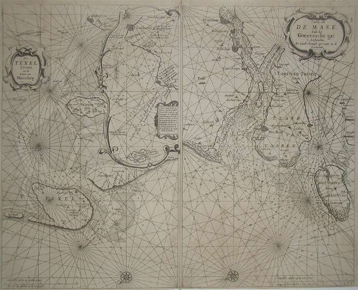
a. De Texel Stroom en de Gaten van Marsdiep. Inset (c. 24 x 12cm) : Caarte vande Rede en Haven van Medenblick hoemen...
Eigenschaften
- Published: Jacques & Gasper Anthoine , Amsterdam
- Published date: 1662
- Type: Antique Map, map
- Technique: Copper engraving / Uncolored
- Issue date: 1662
- Category: Texel and Maase river
- Size: 432 by 540mm (17 by 21¼ inches).
- Bibliography: Koeman Jac. 14 (and a variant of Jac 33) #36
- Stock number: 15961
- Condition: A strong impression in overall good to very good condition, however there are two older very carefully mended tears or thin places in the paper of the 'Maase' map (in the blank sea between right of the lower centerfold and the compass-rose. 432 by 540mm (17 by 21¼ inches).
Article description
Article description
Two sea-charts on one doublepage. The left one is showing Medenblick, Texel and Wieringen. Additional there is a small inset of Medenblick and Enckhuysen. On the other map the area of the river Maase with Rotterdam, Scheidam towards West Voeren is detailled shown. Both maps are ornated with title-cartouches and compass-roses. As well we find a milage scales to convert Dutch, English & French leagues to degrees. The maps are very accurately engraved, towns, harbour-places, sandbanks, depths are marked.Koeman Jac. 14 (and a variant of Jac 33) #36
You might also be interested in the following products
 Tienen. - Tiena
 Copper engraving, uncolored as published in the townbook "Civitates Orbis Terrarum" by Georg Braun and...
€300.00
 Bergen op Zoom
 Original copper engraving, published ca. 1588 in volume III of the town book 'Civitates Orbis Terrarum' by...
€395.00
 Duynkercke. -...
 Original copper engraving, hand colored in wash, published 1578 in the townbook 'Civitates Orbis Terrarum' by Braun...
€395.00
 Gelriae, Cliviae,...
 Original antique copper engraving, published 1612 in a Italian text edition of the 'Theatrum Orbis...
€495.00
Recently viewed products