Theunis, Jacobsz & Lootsman, Jacob and Casparus
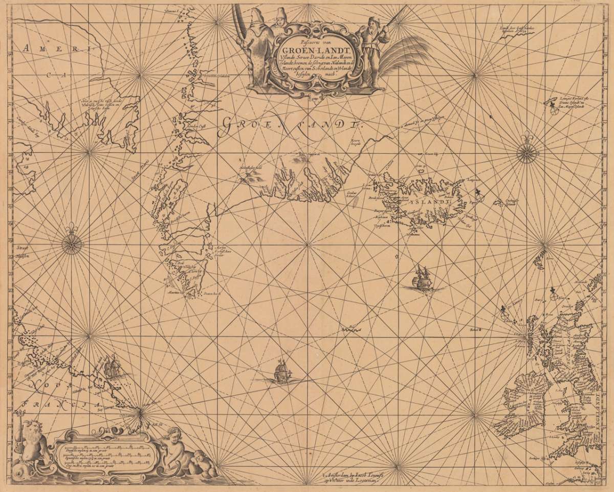
Pascaerte van Groen-Landt, Yslandt, Straet Davids en Ian Mayen eylandt; hoemen de selvrige van Hilandt en de Noort...
Eigenschaften
- Published: Jacques & Gasper Anthoine , Amsterdam
- Published date: 1662
- Type: Antique Map, map
- Technique: Copper engraving / Uncolored
- Issue date: 1662
- Category: North Atlantic with Greenland, Iceland and Nova Francia.
- Size: 426 by 533mm (16¾ by 21 inches).
- Bibliography: Burden #372, 2nd state of 4; Koeman IV, pp. 223-4 & 231 Jac. 1.9 & Jac. 19B.25
- Stock number: 15989
- Condition: A strong impression in excellent condition.
Article description
Article description
Rare seachart by Jacobsz Theunis of the North Atlantic, showing prominent Greenland, Iceland and parts of the North American continent. The map is decorated with a large figurative title cartouche in the upper center, as well with compass roses, ships and an allegoric ornated decorative milage scale. 'Derived from the Goos, 1650, this chart's progenitor was actually by his father, Theunis Jacobsz, c. 1649. Centred on the North Atlantic, it concentrated on providing information on the approaches to the North West Passage. Terra Nova is omiited as it was on the Goos. At first Jacob adopted his father's name, being known as Jacob Theunisz. Later with his brother, Caspar, in association, they applied the noun Lootsman to their name to avoid confusion.... In 1666 Jacob Lootsman published the first known edition of the Nieuwe Water-Werelt, Ofte Zee-Atlas, which also encluded this map.' -Burden #372. Our copy of the map here can be dated c. 1662, it was bound with a collection of seacharts (French text edition of his atlas 'Le Grand & Nouveau Miroir ou Flambeau De la Mer...') by J. Theunis, the engraved title was definitly dated 1662.Burden #372, 2nd state of 4; Koeman IV, pp. 223-4 & 231 Jac. 1.9 & Jac. 19B.25
You might also be interested in the following products
 Wassily...
 Erste Ausgabe. Die Texte von M. Bill, Jean Arp, Carola Giedion-Welcker, Nina Kandinsky, Alberto Magnelli, u.a....
€120.00
DLM No. 65 –... Folio. 20 unnum. SS., 2nd edition, illustrated with 14 reproduced drawings by Giacometti (3 of them printed as color...
€145.00
Die Zwille Mit Schutzumschlag und im In Orig.-Schuber. - Erstausgabe. Exemplar 108 von 200 nummerierten Exemplaren der von Ernst...
€145.00
Recently viewed products