Meyer, Joseph
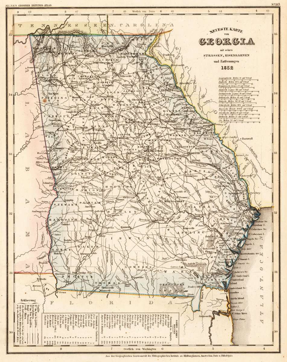
Neuste Karte von Georgia mit seinen Strassen, Eisenbahnen und Entfernungen 1852.
Meyer, Joseph – Neuste Karte von Georgia mit seinen Strassen, Eisenbahn... · Antique Map, Steel Engraving · 370 x 295mm · Bibliograph. Institut, Hildburghaus...
Eigenschaften
- Published: Bibliograph. Institut , Hildburghausen
- Published date: 1852
- Type: Antique Map, map
- Technique: Steel engraving, original color
- Category: Georgia
- Issue date: 1852
- Size: 370 by 295mm (14 by 11 inches).
- Stock number: 25642
- Condition: In excellent condition. 370 by 295mm (14 by 11 inches).
Article description
Article description
Steel Engraving, hand-colored in outline by Meyer, Joseph, published 1852 by Bibliograph. Institut, Hildburghausen. Image size: 370 by 295mm (14 by 11 inches). From Meyer's acclaimed steel-engraved atlas, one of the finest German cartographic productions of the 19th century. Joseph Meyer (1796–1856) was one of the most prolific and influential German publishers of the 19th century. Born in Gotha, he founded the Bibliographisches Institut, which he moved to Hildburghausen in 1828, and built it into a leading European publishing house. Meyer produced numerous finely engraved atlases, including the celebrated Meyer's Groẞer Hand-Atlas (1843–1860), engraved with exceptional precision on steel plates by his talented team of cartographers including Carl Radefeld. His maps of North American states from the 1840s and 1850s are based on the best available American sources of the period, including Tanner's surveys, and offer a detailed German perspective on the rapidly expanding United States. Meyer's steel engravings, often hand-colored in outline, are treasured by collectors for their technical perfection and historical accuracy. This antique map of Neuste Karte von Georgia mit seinen Strassen, Eisenbahnen un was published in 1852 by Bibliograph. Institut, Hildburghausen (370 by 295mm (14 by 11 inches).). It is printed as a steel engraving, hand-colored in outline. The map documents the region with careful attention to rivers, settlements, roads, and political boundaries, reflecting the geographical knowledge available at the time of publication and offering an invaluable primary source for historians and collectors of North American antique cartography. In excellent condition.Meyer, Joseph – Neuste Karte von Georgia mit seinen Strassen, Eisenbahn... · Antique Map, Steel Engraving · 370 x 295mm · Bibliograph. Institut, Hildburghaus...
You might also be interested in the following products
 Gray's New...
 Lithograph, original color in outline by Gray, Frank, published 1884 by O.W. Gray & Son, Philadelphia. Image...
€70.00
Recently viewed products