Smith, J. Calvin
(Illinois, Indiana and Ohio)
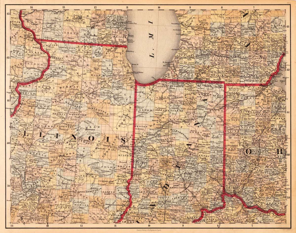
Smith, J. Calvin – (Illinois, Indiana and Ohio) · Antique Map, Lithograph · 373 x 479mm · Th. Fischer, Cassel 1845
Eigenschaften
- Published: Th. Fischer , Cassel
- Published date: 1845
- Type: Antique Map, map
- Technique: Lithograph / Original color.
- Issue date: 1845
- Category: Illinois, Indiana & Ohio
- Size: 373 by 479mm (14 by 18 inches).
- Stock number: 20544
- Condition: In very good to excellent condition. A few small marginal mended tears at the blank bottom (not affecting the image of the map) and a few minor marginal pin holes. 373 by 479mm (14 by 18 inches).
Article description
Article description
Lithograph, original color in outline by Smith, J. Calvin, published 1845 by Th. Fischer, Cassel. Image size: 373 by 479mm (14 by 18 inches). From Smith's multi-sheet Special-Karte — one of the most detailed and accurate mid-19th-century maps of the United States. John Calvin (J. Calvin) Smith (c.1809–1890) was an American surveyor, geographer, and engraver active in New York City from the 1840s. Working with partners including George Sherman (under the Sherman & Smith imprint, 1840–1853) and later in association with J.H. Colton, Smith produced some of the most accurate and widely used general-purpose maps of the United States of his era. His maps appeared in government publications, military surveys, and commercial atlases, and his multi-sheet Special-Karte der Vereinigten Staaten (published in a German-language edition) brought American cartographic standards to European audiences. Despite his prolific output and importance to American cartographic history, much of Smith's personal biography remains obscure. This decorative map shows Illinois, Indiana and a part of Ohio. Further the southern part of Lake Michigan is shown. Inside the map are many place names, rivers, lakes, etc. engraved. The various counties are colored in wash and explicitly detailed named. In very good to excellent condition. A few small marginal mended tears at the blank bottom (not affecting the image of the map) and a few minor marginal pin holes.Smith, J. Calvin – (Illinois, Indiana and Ohio) · Antique Map, Lithograph · 373 x 479mm · Th. Fischer, Cassel 1845
You might also be interested in the following products
 Die Staaten von...
 Steel Engraving, hand-colored in outline by Meyer, Joseph, published 1846 by Bibliograph. Institut, Hildburghausen....
€125.00
 Carte...
 Copper Engraving, hand-colored in outline by Buchon, Jean Alexandre, published 1825 by J. Carez, Paris. Image size:...
€280.00
 Minnesota
 Lithograph, hand-colored in outline by Gray, Frank, published 1884 by O.W. Gray & Son, Philadelphia. Image size:...
€90.00
 North America...
 Steel Engraving, hand-colored in outline by SDUK (Society for the diffusion of useful knowledge), published 1833 by...
€95.00
Recently viewed products