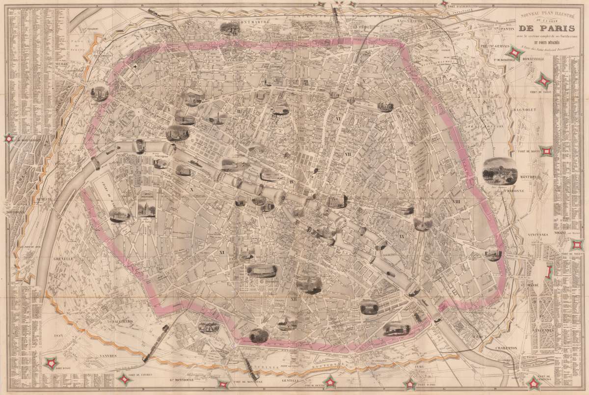
Vuillemin, Alexandre
Nouveau Plan Illustré de la ville de Paris ave le systéme complet de ses Fortifications et forts Détachés A Paris...
Eigenschaften
- Published: Paris
- Published date: 1855
- Issue date: 1855
- Technique: Copper engraving / Original color
- Type: folded map, map
- Category: Plan of Paris
- Size: 575 by 835mm (22¾ by 32¾ inches).
- Stock number: 30262
- Condition: In very good to excellent condition.
Article description
Article description
Copper engraving, hand colored when published. Fine engraved pictorial city plan of Paris, depicting the fortification around various neighborhoods hand colored in outline as published. With an extensive list of street names and places, decorated within the map with fine engraved views of buildings, parks, monuments, etc. This fine plan of Paris by Alexandre Vullemin shows the city of Paris with its fortifications, the,Thiers Wall', which was completed in 1846. The Thiers wall (Enceinte de Thiers) was the last of the defensive walls of Paris. It was an enclosure constructed between 1841 and 1846 and was proposed by the French prime minister Adolphe Thiers but was actually implemented by his successor. (Wikipedia) The plan shows Paris divided up into its quarters with many details on places, churches, bridges etc. The map was originally published folded, the old folds are still slightly visible, a few tiny wholes at some the old folds, one small mended split at one fold in the lower right corner. All without losses. Together with its original blue cardboard cover.You might also be interested in the following products
 Wassily...
 Erste Ausgabe. Die Texte von M. Bill, Jean Arp, Carola Giedion-Welcker, Nina Kandinsky, Alberto Magnelli, u.a....
€120.00
DLM No. 65 –... Folio. 20 unnum. SS., 2nd edition, illustrated with 14 reproduced drawings by Giacometti (3 of them printed as color...
€145.00
Die Zwille Mit Schutzumschlag und im In Orig.-Schuber. - Erstausgabe. Exemplar 108 von 200 nummerierten Exemplaren der von Ernst...
€145.00
Recently viewed products