Waldseemüller, Martin
Lotharingia (Lothringen mit Saarland)
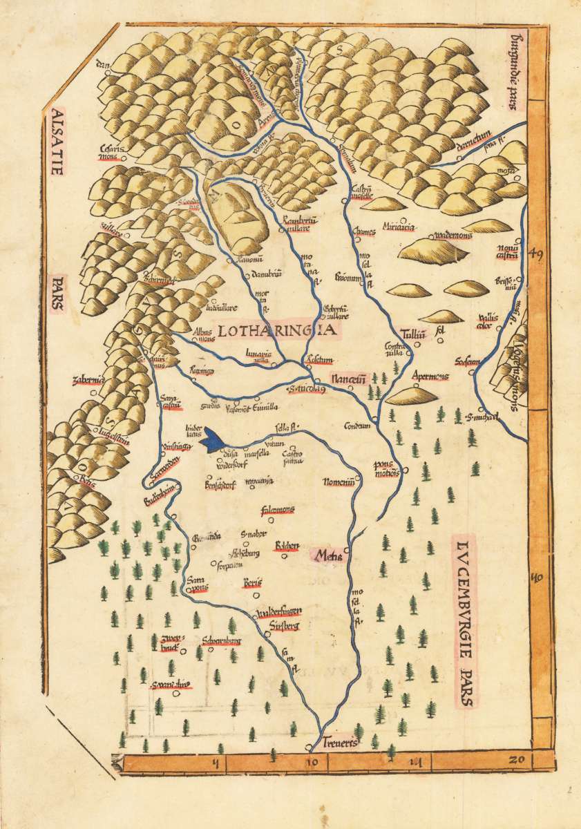
Martin Waldseemüller – Lotharingia (Lothringen mit Saarland) · Original Antique Woodcut · Grüninger · Straßburg 1522
Eigenschaften
- Published: Straßburg
- Published date: 1522
- Technique: Woodcut, original colors.
- Type: map
- Issue date: 1522
- Category: Saarland and Lothringen
- Size: 33.2 x 22,7 cm (13 x 9 inches).
- Bibliography: Speculum Orbis Ausgabe 4. Jahrgang 1988-1993 Seite 79
- Stock number: 33573
- Condition: In excellent condition. Provenance: Peter H. Köhl, illustrated in 'Speculum Orbis issue 4th edition 1988-1993' page 79.
Article description
Article description
Original antique woodcut map of Deutschland. Published by Grüninger, Straßburg, 1522. Sheet: 33.2 x 22,7 cm (13 x 9 inches).. A fine decorative example of antique cartography by Martin Waldseemüller, rich in period detail and historical significance. Martin Waldseemüller (c.1470–1520) was a German cartographer from Saint-Dié-des-Vosges, Lorraine, who produced the revolutionary world map of 1507 — the first document to apply the name 'America' to the New World. Maps derived from or attributed to Waldseemüller, particularly those from the Strasbourg Ptolemy editions of 1513 and 1520, are among the most historically significant in the history of cartography and are extremely rare collector pieces. One of the earliest woodcut maps of the region Saarland and Lothringen with the neighbouring Luxembourg. Waldseemüller deserves the credit of having designed the oldest map of Lorraine and Westrich. After the death of his patron Duke Rene II, he handed a copy of this map over to his son and successor Anton II (1508-1544) in 1508. This unique piece in the large cartographic complete work was probably also an important reason for the Duke's thanks. In 1514 he gave Waldseemüller a canonical in Saint-Dié. Waldseemüller is considered one of the first scientific specialists among the polyhistorically minded humanists of his time. He built on Ptolemy, but realized that his cartographic worldview was outdated. From map to map, he designed a new worldview by bringing together the geographical knowledge of the Middle Ages with the results of the discoveries of the Portuguese and Spaniards. With the Strasbourg Ptolemy Edition in 1513 he deliberately made a distinction between ancient and modern cartography. Since 2005, the Waldseemüller map has been part of the World Document Heritage as a joint proposal by the Library of Congress in Washington D.C. and the German nomination committee for the Memory of the World program. Until 2003, the Waldseemüller card was owned by Prince Johannes zu Waldburg-Wolfegg and Waldsee, located in the Wolfegg Castle library. Since then she has been in the United States of America. Permission to sell the card was granted by the state of Baden-Württemberg and the federal government.Martin Waldseemüller – Lotharingia (Lothringen mit Saarland) · Original Antique Woodcut · Grüninger · Straßburg 1522
Speculum Orbis Ausgabe 4. Jahrgang 1988-1993 Seite 79
You might also be interested in the following products
 Artesia
 Original antique copper engraving, hand coloured when published, depicting Artois. Published by M. Seutter, Augsburg,...
€145.00
 Artesia. Iacobo...
 Original antique copper engraving, hand coloured when published, depicting Artois. Published in Antwerpen, 1588....
€295.00
 Elsass
 Original antique copper engraving, hand coloured when published, depicting Elsass - Alsatia. Published by Jodocus...
€240.00
 Li contorni di...
 Original antique copper engraving, hand coloured when published, depicting Paris. Published by Antonio Zatta.,...
€180.00
Recently viewed products