Moll, Herman
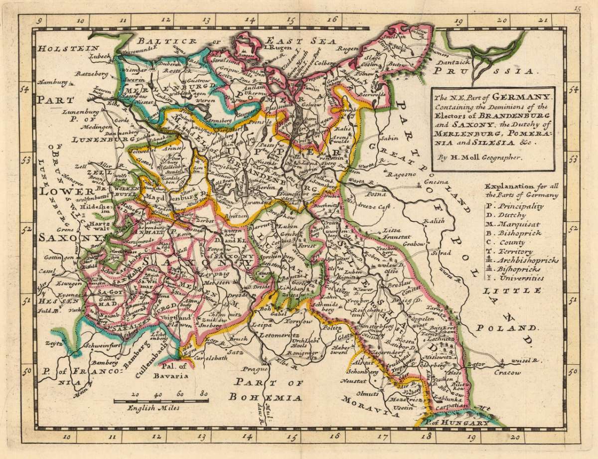
The N.E. Part of Germany Containing the Dominions of the Electors of Brandenburg and Saxony, the Dutchy of...
The N.E. Part of Germany Containing the Dominions of the Electors of Brandenburg and Saxony, the Dutchy of Meklenburg, Pomerania and Silesia &c. By H. Moll G...
Eigenschaften
- Published: Th. Bowles and John Bowles , London
- Published date: 1736
- Type: Antique Map, map
- Technique: Copper engraving / handcolored.
- Issue date: 1736
- Category: Northeast Germany
- Size: 200 by 260mm (7 by 10 inches).
- Stock number: 19552
- Condition: In excellent condition. 200 by 260mm (7 by 10 inches).
Article description
Article description
Hand-Colored Original Copperplate Engraving by Herman Moll, depicting The N.E. Part of Germany Containing the Dominions of the Electors of Brandenburg and Saxony, the Dutchy of Meklenburg, Pomerania and Silesia &c. By H. Moll Geographer.. Published London, Th. Bowles and John Bowles, 1736. Sheet: 200 by 260mm (7 by 10 inches).. A fine and original hand-colored example of Moll's celebrated cartographic work, documenting this region of Germany with the precision and decorative artistry characteristic of the 17300s. Herman Moll was a cartographer active in the 1700s, working in the tradition of European copper-engraved cartography. Their maps are valued by collectors for their historical accuracy and decorative quality. This original copperplate engraving, with original hand coloring depicts the region of The N.E. Part of Germany Containing the Dominions of the Electors of Brandenburg and Saxony, the Dutchy of Meklenburg, Pomerania and Silesia &c. By H. Moll Geographer., published in London, Th. Bowles and John Bowles, 1736. The map records the political and geographic boundaries of the region as understood in 1736, offering a fascinating window into the history of German territorial organization. Sheet measures 200 by 260mm (7 by 10 inches).. In good condition overall, with minor signs of age appropriate for a 18th-century engraving. Ready to frame.The N.E. Part of Germany Containing the Dominions of the Electors of Brandenburg and Saxony, the Dutchy of Meklenburg, Pomerania and Silesia &c. By H. Moll G...
You might also be interested in the following products
 Marchionatus...
 Hand-Colored Original Etching by Matth us Seutter, depicting Marchionatus Brandenburgensis Ducatus Pomeraniae et...
€245.00
 Marchionatus...
 Hand-Colored Original Copperplate Engraving by Jean Covens & Cornelius Mortier, depicting Marchionatus...
€320.00
 Ducatus...
 Hand-Colored Original Copperplate Engraving by Rainer Ottens & Josua, depicting Ducatus Meklenburgicus in quo...
€350.00
 Ducatus...
 Hand-Colored Original Copperplate Engraving by Frederick de Wit, depicting Ducatus Meklenburgicus in quo sunt Ducatus...
€400.00
Recently viewed products