Fer, de Nicolaus.
Le Royaume de Naples - Par N. de Fer. Geographie de Monseigneur le Dauphin. A Paris, chez l'Auteur sur le Quay de...
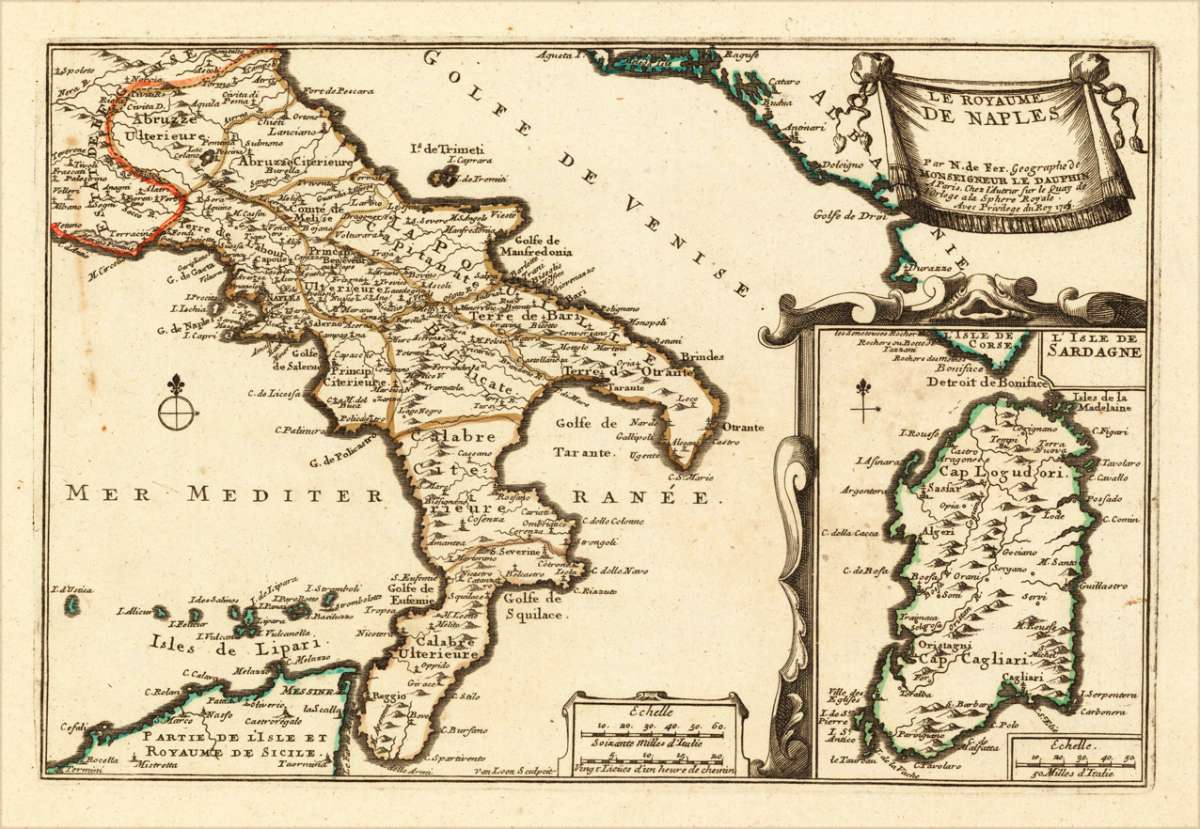
Fer, de – Kingdom of Naples · Copper Engraving, Hand Colored · Introduction à la Géographie, Paris · 1705
Eigenschaften
- Published: N. de Fer , Paris
- Published date: 1705
- Technique: Copper engraving / Original color.
- Type: Antique Map, map
- Issue date: 1705
- Category: Southern Italy
- Size: 223 by 335mm (8 by 13 inches).
- Stock number: 15703
- Condition: In excellent condition. 223 by 335mm (8 by 13 inches).
Article description
Article description
Original antique hand-colored copper engraving, published 1705. Depicting Kingdom of Naples, this map is a fine example of 0s European cartography. Image: 223 by 335mm (8 by 13 inches). An attractive and historically significant 18th-century map for the discerning collector. Nicolas de Fer (1646–1720) was a prominent French cartographer, engraver, and publisher based in Paris. After inheriting his father's mapmaking business, de Fer built it into one of the most productive cartographic firms in France, eventually becoming Geographer to King Louis XIV of France and King Philip V of Spain. His output was prolific—more than 600 sheet maps, town plans, and atlases—covering Europe, the Americas, and beyond. De Fer's maps are known for their decorative cartouches, attractive hand coloring, and commercial appeal, though they were sometimes criticized for prioritizing artistry over accuracy. His maps are particularly associated with the campaigns of the War of the Spanish Succession and are sought by collectors for their decorative quality. This decorative map show the Southern part of Italy with Sicily. Inside the map are many place names, rivers, mountains, etc. engraved. In the upper right corner we see the title cartouche. In the lower right corner we see an inset map, which shows the island Sardinia. At the bottom are two mileage scales. A fine example from Introduction à la Géographie, Paris, sought after by collectors of antique maps of Italy, antique maps of Kingdom of Naples, and antique hand-colored copper engravings for sale. In very good condition. Light age-toning to the sheet, as expected for a 18th-century map.Fer, de – Kingdom of Naples · Copper Engraving, Hand Colored · Introduction à la Géographie, Paris · 1705
You might also be interested in the following products
 Pedemontanae...
 Original antique copper engraving, uncolored, from the 'Theatrum Orbis Terrarum' by Abraham Ortelius, the...
€650.00
 Naples & Sicily
 Original antique lithograph, published 1852. Depicting Kingdom of Naples, this map is a fine example of 0s European...
€145.00
 Milane States
 Original antique hand-colored lithograph, published 1852. Depicting Milan & Lombardy, this map is a fine example...
€140.00
 Les Environs De...
 Original antique hand-colored copper engraving, published 1700. Depicting Kingdom of Naples, this map is a fine...
€170.00
Recently viewed products