Radefeld, Hauptmann von
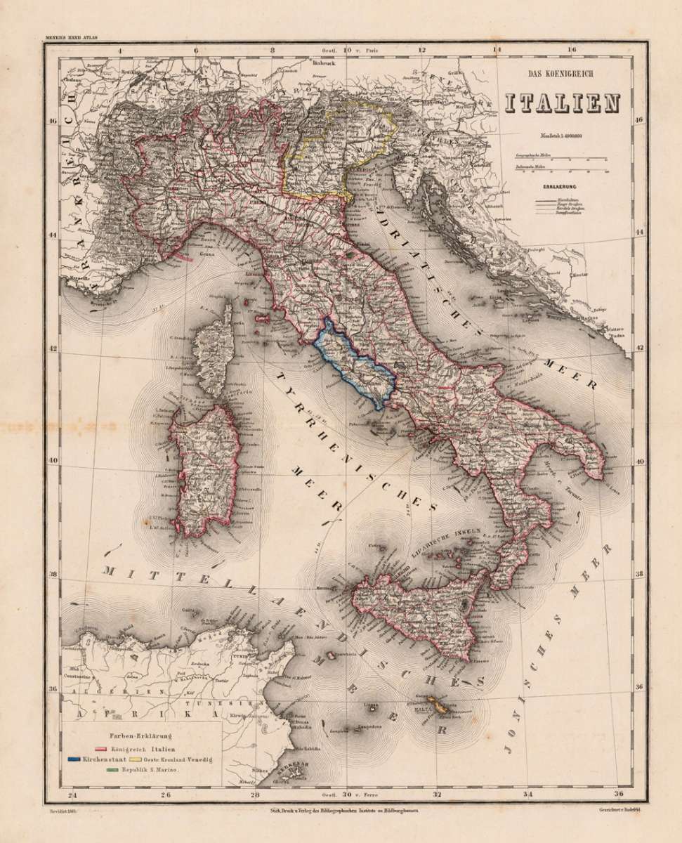
Das Koenigreich Italien
Radefeld, Hauptmann – Italian States · Steel Engraving, Hand Colored · published Hildburghausen · 1865
Eigenschaften
- Published: Bibliograph. Institut , Hildburghausen
- Published date: 1865
- Type: Antique Map, map
- Technique: Steel engraving, original color
- Issue date: 1865
- Category: Italy
- Size: 372 by 297mm (14 by 11 inches).
- Stock number: 19083
- Condition: In excellent condition. 372 by 297mm (14 by 11 inches).
Article description
Article description
Original antique hand-colored steel engraving, published 1865. Depicting Italian States, this map is a fine example of 0s European cartography. Image: 372 by 297mm (14 by 11 inches). An attractive and historically significant 19th-century map for the discerning collector. Hauptmann von Radefeld was a German military cartographer whose work was published by the Bibliographisches Institut in Hildburghausen (later Leipzig), one of the most active German geographical publishers of the mid-19th century. His map of the Kingdom of Italy (1865) was produced during the period of Italian unification, capturing the newly consolidated Italian state. Map of the kingdom of Italy revised 1865. With many engraved names of cities, regions, etc. The political borders are shown in outline colors. A small table of explanation for the colors. A fine example from published Hildburghausen, sought after by collectors of antique maps of Italy, antique maps of Italian States, and antique hand-colored steel engravings for sale. In good condition. Colors well-preserved.Radefeld, Hauptmann – Italian States · Steel Engraving, Hand Colored · published Hildburghausen · 1865
You might also be interested in the following products
 Pedemontanae...
 Original antique copper engraving, uncolored, from the 'Theatrum Orbis Terrarum' by Abraham Ortelius, the...
€650.00
 Naples & Sicily
 Original antique lithograph, published 1852. Depicting Kingdom of Naples, this map is a fine example of 0s European...
€145.00
 Milane States
 Original antique hand-colored lithograph, published 1852. Depicting Milan & Lombardy, this map is a fine example...
€140.00
 Les Environs De...
 Original antique hand-colored copper engraving, published 1700. Depicting Kingdom of Naples, this map is a fine...
€170.00
Recently viewed products