Meyer, Joseph
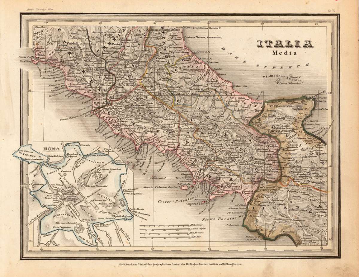
Italia Media
Meyer, Joseph – Rome & Latium · Steel Engraving, Hand Colored · published Hildburghausen · 1844
Eigenschaften
- Published: Bibliograph. Institut , Hildburghausen
- Published date: 1844
- Type: Antique Map, map
- Category: Central Italy
- Issue date: 1844
- Technique: Steelengraving, original colour
- Size: 213 by 279mm (8 by 11 inches).
- Stock number: 19099
- Condition: In excellent condition.
Article description
Article description
Original antique hand-colored steel engraving, published 1844. Depicting Rome & Latium, this map is a fine example of 0s European cartography. Image: 213 by 279mm (8 by 11 inches). An attractive and historically significant 19th-century map for the discerning collector. Joseph Meyer (1796–1856) was a German publisher and encyclopaedist, founder of the Bibliographisches Institut in Hildburghausen, which became one of Germany's most important encyclopaedic and cartographic publishing houses. Meyer's geographical atlases, produced in the 1840s, are known for their fine steel engraving, attractive hand coloring, and scholarly accuracy. His maps were widely distributed throughout Europe and are among the most collectible mid-19th-century German cartographic productions. Detailed antique map of Central Italy with many placenames, engraved rivers, antique places and old streets. Equipped in the left corner with a plan of the 'Antique Rome'. A fine example from published Hildburghausen, sought after by collectors of antique maps of Italy, antique maps of Rome, and antique hand-colored steel engravings for sale. In good condition. Colors well-preserved.Meyer, Joseph – Rome & Latium · Steel Engraving, Hand Colored · published Hildburghausen · 1844
You might also be interested in the following products
 Pedemontanae...
 Original antique copper engraving, uncolored, from the 'Theatrum Orbis Terrarum' by Abraham Ortelius, the...
€650.00
 Naples & Sicily
 Original antique lithograph, published 1852. Depicting Kingdom of Naples, this map is a fine example of 0s European...
€145.00
 Milane States
 Original antique hand-colored lithograph, published 1852. Depicting Milan & Lombardy, this map is a fine example...
€140.00
 Les Environs De...
 Original antique hand-colored copper engraving, published 1700. Depicting Kingdom of Naples, this map is a fine...
€170.00
Recently viewed products