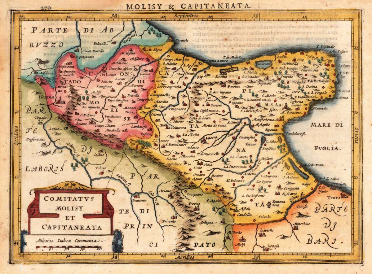
Hondius, Jodocus, Jr.
Comitatus Molisy et Capitaneata.
Hondius, Jodocus – Molise & Capitanata · Copper Engraving, Hand Colored · Nova et Accurata Italiae Hodiernae Descriptio, Leiden 1627 · 1627
Eigenschaften
- Published: Abraham Elsevir , Leiden
- Published date: 1627
- Type: Antique Map, map
- Technique: Copper engraving / handcolored.
- Issue date: 1627
- Size: 188 by 268mm (7 by 10 inches).
- Stock number: 19912
- Condition: In excellent condition. 188 by 268mm (7 by 10 inches).
Article description
Article description
Original antique hand-colored copper engraving, from the rare atlas-townbook 'Nova et Accurata Italiae Hodiernae Descriptio', published by Abraham Elzevier in Leiden, 1627. Depicting Molise & Capitanata, this map is a fine example of 0s European cartography. Image: 188 by 268mm (7 by 10 inches). An attractive and historically significant 17th-century map for the discerning collector. Jodocus Hondius Junior (1594–1629) was a Dutch cartographer and publisher, son of the renowned Jodocus Hondius. He contributed to the family's atlas production and collaborated on the celebrated publication 'Nova et Accurata Italiae Hodiernae Descriptio' (1627), published in Leiden by Abraham Elzevier. This rare hybrid atlas-townbook combined regional maps of Italy with bird's-eye views and plans of Italian towns and fortifications—one of the most detailed contemporary surveys of Italy published in the 17th century. The publication is notable for combining maps with townscapes in a single volume, making it a prime source for the study of early modern Italian urban geography. The map shows the region 'Comitatus Molisy et Capitaneata.' around 1627. This rare historic map was engraved by Jodocus Hondius and was published here in this rare combination of an atlas and town book 'Nova et Accurata Italiae Hodiernae Descriptio...' for the first time. This map is decorative ornated with a renaissance title cartouche and a small mileage scale. Further this antique map provides a lot of information on place names, rivers, lakes, mountains, etc. Along the coast we find many islands engraved. The map is decorative hand colored in wash and outline. Printed on good paper on the full sheet as published. A fine example from Nova et Accurata Italiae Hodiernae Descriptio, Leiden 1627, sought after by collectors of antique maps of Italy, antique maps of Molise, and antique hand-colored copper engravings for sale. In good condition consistent with age. Light age-toning to the sheet, as expected for a 17th-century engraving. Centerfold as published.Hondius, Jodocus – Molise & Capitanata · Copper Engraving, Hand Colored · Nova et Accurata Italiae Hodiernae Descriptio, Leiden 1627 · 1627
You might also be interested in the following products
 Pedemontanae...
 Original antique copper engraving, uncolored, from the 'Theatrum Orbis Terrarum' by Abraham Ortelius, the...
€650.00
 Naples & Sicily
 Original antique lithograph, published 1852. Depicting Kingdom of Naples, this map is a fine example of 0s European...
€145.00
 Milane States
 Original antique hand-colored lithograph, published 1852. Depicting Milan & Lombardy, this map is a fine example...
€140.00
 Les Environs De...
 Original antique hand-colored copper engraving, published 1700. Depicting Kingdom of Naples, this map is a fine...
€170.00
Recently viewed products