Seutter, Matthäus
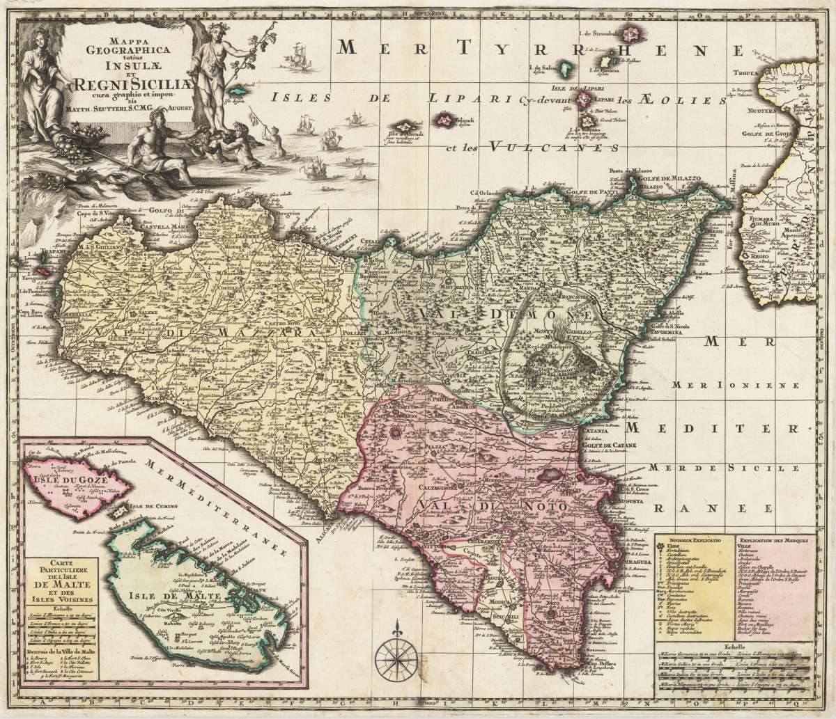
Mappa Geographica totius Insulae et Regni Siciliae cur graphio et impensis Matth. Seutteri, S.C.M.G. August.
€475.00
Prices incl. VAT plus shipping costs
This item is sold. Please contact us if you are searching for this item.
Eigenschaften
- Published: Augsburg
- Published date: 1730
- Issue date: 1720-30
- Category: Italy
- Technique: Copper engraving / Original color
- Type: map
- Size: 502 by 584mm (19¾ by 23 inches).
- Stock number: 30295
- Condition: A larger part of the lower centre fold with careful restauration (the compass rose was missing and is redrawn). Overall in good condition.
Article description
Article description
Original copper engraving hand colored in outline and wash when published. This beautiful old colored map depicts the island of Sicily and an inset map of Malta and Gozo. In the upper left corner is an large allegoric title cartouche showing Ceres or Abundance, Bacchus, and Neptune accepting the bounty of the seas. The description and a mileage scale is in the lower right corner. With many place names, rivers, mountains, further also a scene of the Vulcano mount Etna in full eruption is engraved. A fine decorative 18th century map of Sicily by the famous German mapmaker Matthaeus Seutter. Matthäus Seutter (born September 20, 1678 in Augsburg; † March 1757 there) was a German cartographer and engraver as well as the founder of the Seutter printing company and publishing house. Born the son of a goldsmith, Seutter began an apprenticeship with Johann Baptist Homann in Nuremberg after 1697. Returning to his hometown of Augsburg, he initially worked in the publishing house of Jeremias Wolff (1663–1724). Around 1707 he founded his own company with a printing and publishing house. There he produced large numbers of maps, city maps, genealogical diagrams and other motifs. He also brought out a pair of globes (terrestrial and celestial globes). By copying his teacher Homann's successful concept, he soon became his biggest competitor. However, only a few original maps were published by Seutter, which was certainly due to the fact that Augsburg had neither a university nor a mathematical and scientific environment at the time. Many of his maps are literally "copied" from other cartographers' templates, i.e. copies. At most, they deviated from the originals in the artistic design with lavish baroque cartouches and allegorical scenes. Seutter initially made his own cards, but in later years he was, among other things, supported by his sons Georg Matthäus and Albrecht Carl and by Tobias Conrad Lotter; Augsburg artists such as Martin Gottfried Crophius (1717–1765), Melchior Rhein and Gottfried Rogg (1669–1742) were used for the decorative elements. Around 400 large-format and more than 60 small-format copperplate engravings were created in Seutter's workshop. From 1720 onwards, Seutter also summarized his maps in atlases with different titles, which grew from initially 20 maps (Atlas Compendiosus) to over 300 maps (Atlas Novus, Grosser Atlas). His small-format maps could be purchased individually in cardboard slipcases or as a collective edition (Atlas Minor, from around 1745). Like Homann before him, Seutter also received from Emperor Charles VI in 1731/32. the beautiful but meaningless title Sacrae Caesareae Maiestatis Geographus, that is, Imperial Geographer (abbreviated S.C.Maj. Geogr or SCMG on the maps). In addition, in 1741 he was granted an imperial printing privilege, which, however, only applied to the Swabian and Upper Rhine imperial circles as well as to the area of Franconian law. Johann Adam Riedinger had it engraved by Seutter under the title Tabulae Principatus Brandenburgico-Culmbacensis sive Baruthini pars superior and published in Augsburg. The designs from Riediger's estate became the property of Seutter and later passed on to his son-in-law Tobias Conrad Lotter. After Seutter's death in 1757, his son Albrecht Carl (1722–1762) continued to run the company alone. But he only survived his father by 5 years. His widow then sold about half of the publishing house to Matthäus Seutter's son-in-law Tobias Conrad Lotter and the art publisher Johann Michael Probst (1727–1776), who was also a close relative. They replaced Seutter's name with their own on most of the maps acquired in 1762. (Wikipedia)You might also be interested in the following products
 Pedemontanae...
 Original antique copper engraving, uncolored, from the 'Theatrum Orbis Terrarum' by Abraham Ortelius, the...
€650.00
 Ora Baiana et...
 Original antique hand-colored copper engraving, published 1719. Depicting Bay of Naples, this map is a fine example...
€175.00
 Naples & Sicily
 Original antique lithograph, published 1852. Depicting Kingdom of Naples, this map is a fine example of 0s European...
€145.00
 Milane States
 Original antique hand-colored lithograph, published 1852. Depicting Milan & Lombardy, this map is a fine example...
€140.00
Recently viewed products