Jaillot, Alexis-Hubert & Mortier, Pierre
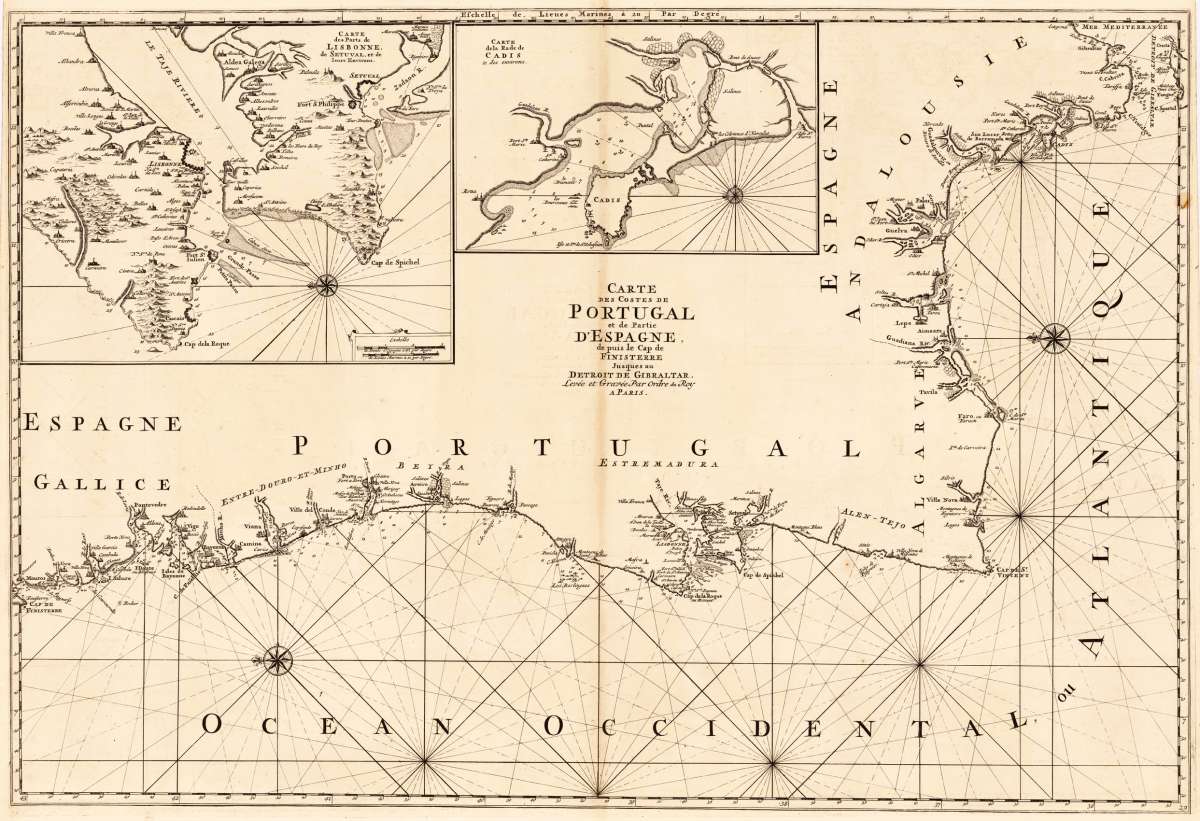
Carte des Costes de Portugal et de Partie d`Espagne, de puis le Cap de Finisterre Jusques au Detroit de Gibraltar....
Eigenschaften
- Published: P. Mortier. , Amsterdam
- Published date: 1705
- Type: Antique Map, map
- Technique: Copper engraving / Uncolored
- Issue date: 1705
- Category: Galicia & Portugal
- Size: 590 by 870mm (23¼ by 34¼ inches).
- Stock number: 19172
- Condition: A fine example in excellent condition.
Article description
Article description
Copper engraving, uncolored as published. A fine example of a strong impression of this large map. This issue is published and printed at Pierre Mortier in Amsterdam 1705. The map was printed from two plates. This decorative sea chart is orientated with the north to the left and is equipped with engraved lines for navigation and a compass rose. It shows the coast from Galicia all along Portugal towards Andalusia and Gibraltar. With many engraved place names along the coasts, anchor places and engraved depths in the water. Cities and larger towns are engraved as miniature city views. At the top the map is equipped with two inset maps: the port of Lisboa and the bay of Cadiz. Hubert Jaillot's maps can be treated as a masterpiece of the French baroque cartography in the 17th century. It took Nicolaus Sanson and Hubert Jaillot a period of about fifteen years to complete this enormous work (c. 1681-96). The atlas was dedicated to Ludwig XIV.You might also be interested in the following products
 Zahara - Bornos
 Original antique hand colored copper engraving, published in volume V of the town book "Civitates Orbis...
€480.00
 De Cust van...
 Detailled handcoloured sea-chart showing the Portugese coastline from Setubal S. Vves along the Algarve towards Palos...
€850.00
 Partie...
 Copper engraving, hand colored in outline, when published. Decorative map of Portugal. Divided up by outline color...
€245.00
 Der Thurm Belem...
 Copper engraving, hand colored in wash and outline, published in Allain Manesson Mallet's description of the...
€55.00
Recently viewed products