Jansonnius, Joan.
Pascaart vande Custen Van Andaluzia, Portugal, Gallißien, Biseajen, en eengedeelt von Vranckyck, beginnen van Heysant...
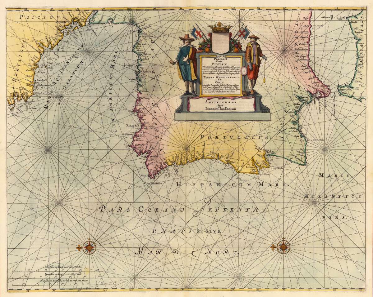
Eigenschaften
- Published: J. Janssonius , Amsterdam
- Published date: 1650
- Type: Antique Map, map
- Technique: Copper engraving / later hand color
- Category: Andaluzia
- Issue date: 1650/55
- Size: 436 by 548mm (17 by 21 inches).
- Stock number: 23094
- Condition: Full margins as published. Minor skillfully restorations at the upper and lower centre fold, else in excellent condition. 436 by 548mm (17 by 21 inches).
Article description
Article description
Original antique copper engraving, hand colored in outline when published. A highly decorative sea chart of Spain with the adjacent North Africa and the 'Gulf of Biscay'. Ornated with a highly decorative engraved title cartouche with Spanish noblemen and coats of arms. Further the map is ornated with two compass roses and the pascaart is orientated North to the left. Joan Jansson's sea-atlas can be regarded as the first Dutch sea atlas in this period, which covered the entire world. Johannes Janssonius (1588, Arnhem – buried July 11, 1664, Amsterdam) (born Jan Janszoon, in English also Jan Jansson) was a Dutch cartographer and publisher who lived and worked in Amsterdam in the 17th century. Janssonius was born in Arnhem, the son of Jan Janszoon the Elder,[1] a publisher and bookseller. In 1612 he married Elisabeth de Hondt, the daughter of Jodocus Hondius. He produced his first maps in 1616 of France and Italy. In 1623 Janssonius owned a bookstore in Frankfurt am Main, later also in Danzig, Stockholm, Copenhagen, Berlin, Königsberg, Geneva and Lyon. Elisabeth Hondius died in 1627 and he remarried Elisabeth Carlier in 1629. In the 1630s he formed a partnership with his brother in law Henricus Hondius, and together they published atlases as Mercator/Hondius/Janssonius. Under the leadership of Janssonius the Hondius Atlas was steadily enlarged. Renamed Atlas Novus, it had three volumes in 1638, one fully dedicated to Italy. In 1646, a fourth volume came out with "English County Maps", a year after a similar issue by Joan Blaeu. Janssonius' maps are similar to those of Blaeu, and he is often accused of copying from his rival, but many of his maps predate those of Blaeu and/or covered different regions. By 1660, at which point the atlas bore the appropriate name "Atlas Major", there were 11 volumes, containing the work of about a hundred credited authors and engravers. It included a description of "most of the cities of the world" (Townatlas), of the waterworld (Atlas Maritimus in 33 maps), and of the Ancient World (60 maps). The eleventh volume was the Atlas of the Heavens by Andreas Cellarius. Editions were printed in Dutch, Latin, French, and a few times in German. After Janssonius's death, the publishing company was continued by his son-in law, Johannes van Waesbergen. The London bookseller Moses Pitt attempted publication of the Atlas Major in English, but ran out of resources after the fourth volume in 1683. (Wikipedia)You might also be interested in the following products
 Wassily...
 Erste Ausgabe. Die Texte von M. Bill, Jean Arp, Carola Giedion-Welcker, Nina Kandinsky, Alberto Magnelli, u.a....
€120.00
DLM No. 65 –... Folio. 20 unnum. SS., 2nd edition, illustrated with 14 reproduced drawings by Giacometti (3 of them printed as color...
€145.00
Die Zwille Mit Schutzumschlag und im In Orig.-Schuber. - Erstausgabe. Exemplar 108 von 200 nummerierten Exemplaren der von Ernst...
€145.00
Recently viewed products