The following products have been found matching your search "isles": 127
Or did you mean: issues | isle | isla | Isle of Man | islet | british isles | The British Isles | isis
No results were found for the filter!
 Parte della Costa Orientale dell' Africa con l'Isola di Madagascar e le Carte particolari dell' Isole...
 Copper engraving, in contemporary original color in outline. Published in Zatta's "Atlante Novissimo"....
€175.00
 Regnorum Siciliae et Sardiniae nec non Melitae sen Maltae, Insula cum adjectis Italiae et Africae Litoribus Nova...
 Original antique copper engraving in contemporary hand color in wash and outline when published. A very decorative...
€850.00
 Karte von den Eylanden des Grünen Vorgebürges, - nach den Tagebüchern und Anmerkungen der geschicktesten Seefahrer...
 Copper engraving, uncolored as published. This wonderful map shows us the Eylands. In the middle of the map we see a...
€80.00
 Status Ecclesiastici nec non Magni Ducatus Toscanae Nova Tabula Geographica...
 Original antique copper engraving, hand colored in outline when published. A fine impression of this decorative map...
€275.00
 Artesia
 Copper engraving, handcolored when published. Fine detailled engraved map showing Artois after the cartographic...
€145.00
 Hemisphere Septentrional pour voir plus distinctement Les Terres Arctiques Par Guillaume De Lisle de l Academie Rle....
 Copper-engraving, uncoloured as published. Fine example of a strong impression of this large map showing the...
€1,050.00
 Insulae S. Dominicae Tabula Accuratissima.
 Copper engraving handcolored in outline when published. A detailled map covering Haiti (Dominican Republic), the...
€400.00
 Neueste Karte von England nach den besten Quellen entworfen u. gezeichnet vom Hauptm. Radefeld. 1844
 Steelengraving, handcolored in outline when published. The detailled map of the British Isles is providing a lot of...
€80.00
 A New Map of Scotland, from the latest Authorities.
 Copper engraving, handcolored in outline and wash when published. Large and very detailed map of Scotland divided up...
€295.00
 Carte Géographique, Statistique et Historique de la Guadeloupe. - Ile de la Guadeloupe dressée par Pierron, d`aprés...
 Copper engraving, handcolored in wash when published. Fine engraved map of the island of Guadeloupe in the West...
€95.00
 Südlicher Theil von Griechenland und die Insel Candia
 Steel engraving, hand colored in outline and wash. This antique map shows the southern part of Greece with the isle...
€150.00
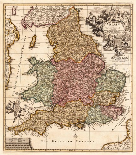
 Angliae Regnum tam in septem Antiqua Anglo-Saxonum Regna quam in omnes Hodiernas Regiones accuratissime distinctum...
 Copper engraving, hand colored in outline and wash. Decorative antique map showing England, Isle of Man and a part...
€445.00

