Smith, J. Calvin
(Vermont - New Hampshire - Maine - New Brunswick)
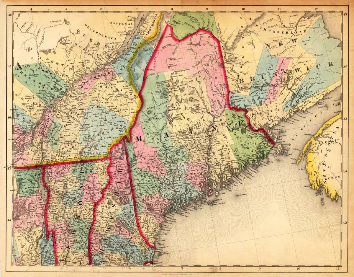
Smith, J. Calvin – (Vermont - New Hampshire - Maine - New Brunswick) · Antique Map, Lithograph · 370 x 475mm · Th. Fischer, Cassel 1845
Eigenschaften
- Published: Th. Fischer , Cassel
- Published date: 1845
- Type: Antique Map, map
- Issue date: 1845
- Technique: Lithograph, later handcolor.
- Category: Maine, Northeastern US
- Size: 370 by 475mm (14 by 18 inches).
- Stock number: 14251
- Condition: In very good condition. A few small marginal mended tears at the blank margins, verso old backed (not affecting the image of the map). 370 by 475mm (14 by 18 inches).
Article description
Article description
Lithograph, hand-colored in outline by Smith, J. Calvin, published 1845 by Th. Fischer, Cassel. Image size: 370 by 475mm (14 by 18 inches). From Smith's multi-sheet Special-Karte — one of the most detailed and accurate mid-19th-century maps of the United States. John Calvin (J. Calvin) Smith (c.1809–1890) was an American surveyor, geographer, and engraver active in New York City from the 1840s. Working with partners including George Sherman (under the Sherman & Smith imprint, 1840–1853) and later in association with J.H. Colton, Smith produced some of the most accurate and widely used general-purpose maps of the United States of his era. His maps appeared in government publications, military surveys, and commercial atlases, and his multi-sheet Special-Karte der Vereinigten Staaten (published in a German-language edition) brought American cartographic standards to European audiences. Despite his prolific output and importance to American cartographic history, much of Smith's personal biography remains obscure. This antique map shows prominent in its centre the state of Maine with its neighboring states Vermont, New Hampshire and New Brunswick. The map extends from Salisbury in the south towards New Brunswick and the neighboring Nova Scotia. Inside the map are many place names, rivers, lakes, mountains, railroads, etc. Many counties are named and finely hand colored in wash. A detailed map of this part of the Northeastern United States by the famous 19th century mapmaker and cartographer Calvin Smith. In very good condition. A few small marginal mended tears at the blank margins, verso old backed (not affecting the image of the map).Smith, J. Calvin – (Vermont - New Hampshire - Maine - New Brunswick) · Antique Map, Lithograph · 370 x 475mm · Th. Fischer, Cassel 1845
You might also be interested in the following products
 Delaware and...
 Lithograph, color by Johnson & Ward, published 1862 by Johnson & Ward, New York. Image size: 400 by 320mm (15...
€90.00
 Vereinigte...
 Lithograph, hand-colored in outline by Bromme, Traugott, published 1855 by Hoffm.Verlagsbuchhandlung, Stuttgart....
€80.00
 Gray's New...
 Lithograph, original color in outline by Gray, Frank, published 1884 by O.W. Gray & Son, Philadelphia. Image...
€95.00
 Gray's New...
 Lithograph, original color in outline by Gray, Frank, published 1884 by O.W. Gray & Son, Philadelphia. Image...
€95.00
Recently viewed products