Petermann, A.
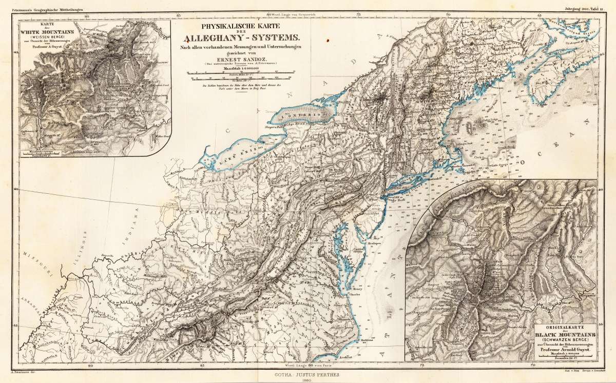
Physikalische Karte des Alleghany-Systems. Nach allen vorhandenen Messungen und Untersuchungen gezeichnet von Ernest...
Petermann, A. – Allegheny System · Lithograph, Hand Coloured · Petermanns Geographische Mitteilungen, Gotha · 1860
Eigenschaften
- Published: Gotha
- Published date: 1860
- Issue date: 1860
- Technique: Lithograph / Original color
- Type: map
- Category: Alleghany Mountains
- Size: 244 by 408mm (9½ by 16 inches).
- Stock number: 27825
- Condition: In excellent condition. The map was originally published folded, so that the old folds are still slightly visible.
Article description
Article description
Original antique lithograph, hand coloured, published by Justus Perthes in Gotha for 'Petermanns Geographische Mitteilungen', 1860. Lithograph, original hand colored color in outline when published. Sheet: 244 by 408mm (9½ by 16 inches).. August Heinrich Petermann (1822–1878) was one of the most important German cartographers and geographers of the 19th century. Born in Bleicherode, Saxony, he trained at the Geographische Kunstschule in Potsdam under Heinrich Berghaus — himself a leading student of Alexander von Humboldt. After a formative decade in Edinburgh and London (1845–1854), where he gained broad experience in the commercial and scientific aspects of cartography, Petermann returned to Gotha and joined the Justus Perthes publishing house. In 1855 he founded 'Petermanns Geographische Mitteilungen' (PGM), which swiftly became one of the world's foremost geographical journals — the definitive record of the great age of exploration and discovery. Petermann personally produced over 500 maps and signed 226 articles in PGM, ranging across Africa, the Polar regions, Asia, and the history and practice of cartography. In 1902, the eminent British cartographer J. G. Bartholomew wrote: 'No one has done more than he to advance modern cartography.' His maps are held in major institutions worldwide, including the Library of Congress, the British Library, and the Bibliothèque nationale de France. This antique map drawn by Ernest Sandoz shows in its centre the Alleghany Mountains with Pennsylvania, the neighboring Ohio and is extending south towards North Carolina. The map has two inset maps which are showing the,White Mountains' and the,Black Mountains', both maps are based on Professor Arnold Guyot. The map is equipped with many small place names, rivers, maountains, etc. In excellent condition. The map was originally published folded, so that the old folds are still slightly visible.Petermann, A. – Allegheny System · Lithograph, Hand Coloured · Petermanns Geographische Mitteilungen, Gotha · 1860
You might also be interested in the following products
 Pensylvanie....
 Copper Engraving, hand-colored in outline by Buchon, Jean Alexandre, published 1825 by Carez, Paris. Image size: 440...
€110.00
 Pennsylvania No:7
 Lithograph, original color in outline by Smith, J. Calvin, published 1855-60 by Theodor Fischer, Kassel. Image size:...
€268.00
 New Map of the...
 Lithograph, hand-colored in outline by Smith, J.L, published 1915 by J. L. Smith, Philadelphia. Image size: 1020 by...
€950.00
 Neueste Karte von...
 Steel Engraving, hand-colored in outline by Meyer, Joseph, published 1845 by Bibliograph. Institut, Hildburghausen....
€65.00
Recently viewed products