Gray, Frank
Indianapolis - Louisville
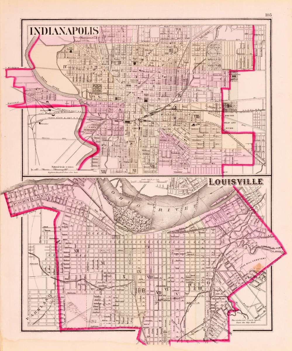
Gray, Frank – Indianapolis - Louisville · Antique Map, Lithograph · 393 x 325mm · O.W. Gray & Son, Philadelphia 1884
Eigenschaften
- Published: O.W. Gray & Son , Philadelphia
- Published date: 1884
- Type: Antique Map, map
- Technique: Lithograph / Original color.
- Issue date: 1884
- Category: Indianapolis and Louisville
- Size: 393 by 325mm (15 by 12 inches).
- Stock number: 19720
- Condition: In excellent condition. 393 by 325mm (15 by 12 inches).
Article description
Article description
Lithograph, original color in outline by Gray, Frank, published 1884 by O.W. Gray & Son, Philadelphia. Image size: 393 by 325mm (15 by 12 inches). From Gray's Atlas — one of the most important American commercial atlases of the post-Civil War era. Frank A. Gray was an American cartographer working in the 1870s and 1880s for the Philadelphia-based firm O.W. Gray & Son, one of the leading commercial map publishers of the post-Civil War United States. Founded by Ormando Willis Gray, a civil and topographical engineer, the firm produced Gray's Atlas of the United States and its many regional successors. Gray's National Atlas was among the most successful commercial atlas ventures of the 1870s and one of the last American atlases to employ hand-coloring. The state maps of the 1880s are noted for their excellent topographical detail, clear depiction of the expanding railroad network, and accurate county boundaries — invaluable primary sources for historians and sought-after collector pieces today. This antique map shows a ground plan of Indianapolis and Louisville. The plans are very detailed with notes for houses, churches, streets, institutions, etc. In excellent condition.Gray, Frank – Indianapolis - Louisville · Antique Map, Lithograph · 393 x 325mm · O.W. Gray & Son, Philadelphia 1884
You might also be interested in the following products
 Johnson's Georgia...
 Lithograph, hand-colored in outline by Johnson & Browning, published 1859 by New York. Image size: 395 by 560mm...
€65.00
 Gray's New...
 Lithograph, original color in outline by Gray, Frank, published 1884 by O.W. Gray & Son, Philadelphia. Image...
€70.00
 Amér.Sep....
 Lithograph, hand-colored in outline by Vandermaelen, Phillippe Marie, published 1825 by Brussels. Image size: 463 by...
€177.00
 L'Ancien et...
 Copper Engraving, uncolored by Bonne, Rigobert, published 1787 by M. Bonne, Paris. Image size: 346 by 235mm (13 by 9...
€195.00
Recently viewed products