Zatta, Antonio
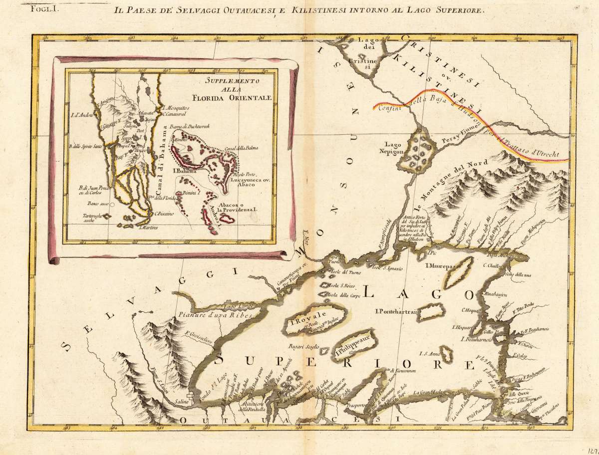
Il Paese de' Selvaggi Outaucesi, e Kilistinesi intorno al Lago Superiore.
Zatta, Antonio – Il Paese de' Selvaggi Outaucesi, e Kilistinesi intorno... · Antique Map, Copper Engraving · 306 x 424mm · Antonio Zatta., Venice 1778
Eigenschaften
- Published: Venice
- Published date: 1778
- Technique: Copper engraving / Original color.
- Issue date: 1778
- Category: Florida & Bahamas
- Type: map
- Size: 306 by 424mm (12 by 16 inches).
- Stock number: 12928
- Condition: In very good to excellent condition, minor browned middle-fold (gluestaining), as often. A tiny minor abrasion within the image of the map (near Saline Fondo d Lago).
Article description
Article description
Copper Engraving, hand-colored in outline by Zatta, Antonio, published 1778 by Antonio Zatta, Venice. Image size: 306 by 424mm (12 by 16 inches). From Zatta's Atlante Novissimo — one of the most important Italian atlases of the 18th century. Antonio Zatta (c.1722–1804) was a prominent Venetian cartographer, engraver, and publisher who flourished between 1757 and 1797. He was awarded the title of Official Geographer to the Republic of Venice, reflecting the high esteem in which his work was held. Zatta is best known for his four-volume Atlante Novissimo (1779–1785), one of the most important Italian atlases of the 18th century. The atlas incorporated the most recent geographical discoveries, including the Pacific islands visited by Captain Cook. His 12-sheet map of the United States (1778), based on John Mitchell's landmark map, is considered one of the finest re-engravings of that seminal work. Zatta's maps are celebrated for their fine craftsmanship, aesthetic quality, and their importance as primary documents of late 18th-century geographical knowledge, making them among the most prized Italian antique maps for collectors today. Published in Zatta's "Atlante Novissimo" as sheet I in his twelve-sheet map of the United States. With the inset map of Southern Florida and the Bahamas (Supplemento alla Florida Orientale). In very good condition. A tiny minor abrasion within the image of the map (near Saline Fondo d Lago).Zatta, Antonio – Il Paese de' Selvaggi Outaucesi, e Kilistinesi intorno... · Antique Map, Copper Engraving · 306 x 424mm · Antonio Zatta., Venice 1778
You might also be interested in the following products
 Gray's New...
 Lithograph, original color in outline by Gray, Frank, published 1884 by O.W. Gray & Son, Philadelphia. Image...
€70.00
 Carte...
 Copper Engraving, hand-colored in outline by Buchon, Jean Alexandre, published 1825 by J. Carez, Paris. Image size:...
€245.00
 Süd Carolina....
 Copper Engraving, uncolored by Drayton, J, published 1806 by Geographisches Institut, Weimar. Image size: 214 by...
€245.00
 Louisiana, Texas...
 Lithograph, original color in outline by Smith, J. Calvin, published 1855-60 by Theodor Fischer, Kassel. Image size:...
€495.00
Recently viewed products