Buchon, Jean Alexandre
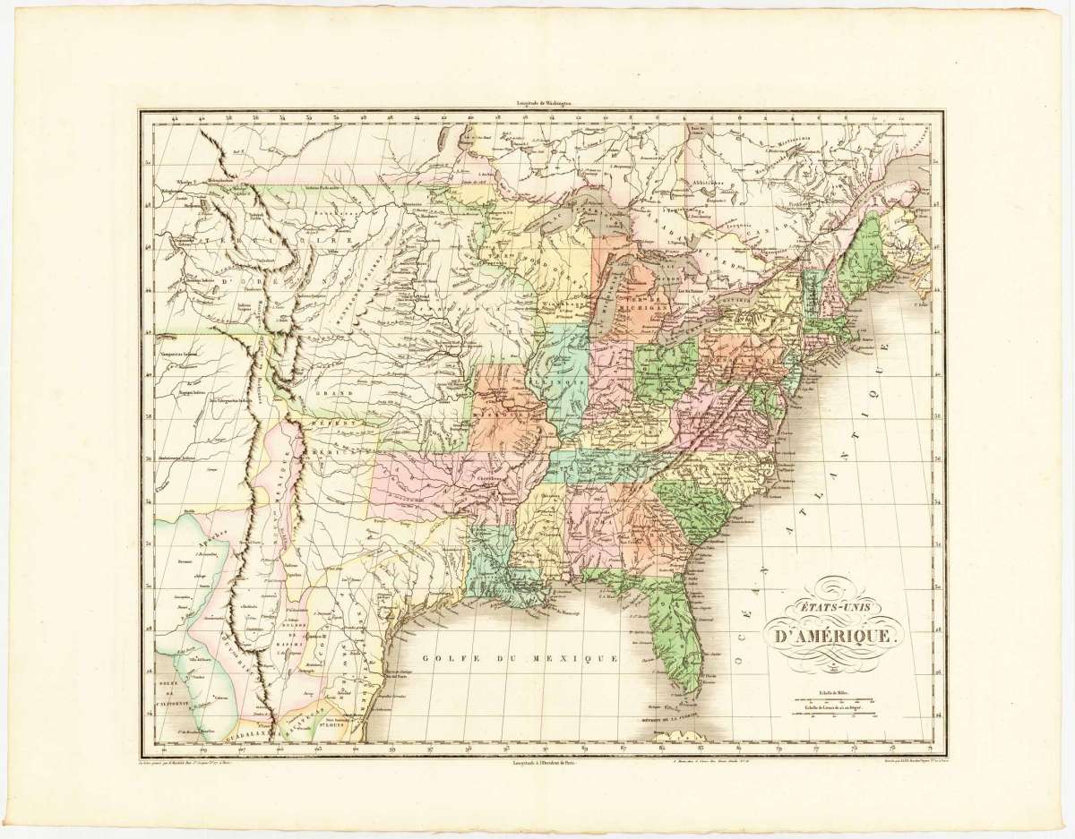
Ètats-Unis D Amerique 1825.
Buchon, Jean Alexandre – Ètats-Unis D Amerique 1825 · Antique Map, Copper Engraving · 426 x 532mm · J. Carez, Paris 1825
Eigenschaften
- Published: Carez , Paris
- Published date: 1825
- Technique: Copper engraving / Original color.
- Type: Antique Map, map
- Issue date: 1825
- Category: United States
- Size: 426 by 532mm (16 by 21 inches).
- Stock number: 23549
- Condition: In excellent condition. 426 by 532mm (16 by 21 inches).
Article description
Article description
Copper Engraving, hand-colored in outline by Buchon, Jean Alexandre, published 1825 by J. Carez, Paris. Image size: 426 by 532mm (16 by 21 inches). A detailed map from Buchon's 1825 Atlas géographique, the French edition of Carey & Lea's celebrated American atlas. Jean Alexandre Buchon (1791–1846) was a French historian and geographer who produced the influential Atlas géographique, statistique, historique et chronologique des deux Amériques et des îles adjacentes (1825), published in Paris by J. Carez. This atlas was the French edition of the celebrated Carey & Lea atlas of the United States. Each map was surrounded by letterpress text describing the economic, political, geographical, and historical statistics of the depicted region in French, making it an extraordinary reference work for European readers at the dawn of the Americas' independence era. The maps were engraved in Paris to the highest standards of the day and remain important primary documents for the study of early 19th-century American geography as understood by European scholars. This edition by Jean Alexandre Buchon was published three years after Carey & Lea s important American Atlas. Jean Buchon issued his revised French edition of the atlas 1825 in Paris. In excellent condition.Buchon, Jean Alexandre – Ètats-Unis D Amerique 1825 · Antique Map, Copper Engraving · 426 x 532mm · J. Carez, Paris 1825
You might also be interested in the following products
 United States...
 Lithograph, hand-colored in outline by Philip, George & Son, published 1852 by Liverpool. Philip & Son. Image...
€130.00
 Vereinigte...
 Lithograph, color by Flemming, Carl, published 1865 by Glogau, Flemming. Image size: 335 by 410mm (13 by 16...
€145.00
 Vereinigte...
 Copper Engraving, hand-colored in outline by Mollo, Tranquillo, published 1807 by Mollo, Vienna. Image size: 320 by...
€345.00
![Antique Special-Karte der Vereinigten Staaten von Nordamerika. [folded maps in cardboard cover]](https://bergbook.com/media/image/cd/c6/1d/20600_500x500@2x.jpg "Special-Karte der") Special-Karte der...
Special-Karte der... Lithograph, color by Smith, J. Calvin, published 1845 by Theodor Fischer, Kassel. Image size: 1440 by 1840mm (56 by...
€4,200.00
Recently viewed products