Theunis, Jacobsz & Lootsman, Jacob and Casparus
De Zee-Custen van Bretaigne, van Heysandt totaen Boelyn. ´t Amsterdam; By Iacob Theunisz, optwater in de Lootsman.
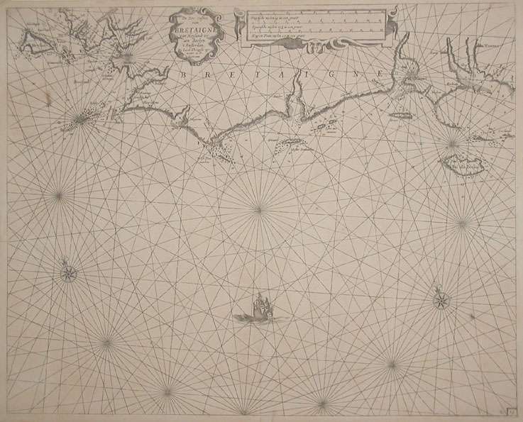
Jacobsz Theunis & Jacob and Casparus Lootsman – De Zee-Custen van Bretaigne, van Heysandt totaen Boelyn.... · Original Antique Copper Engraving, Uncoloured...
Eigenschaften
- Published: Jacques & Gasper Anthoine , Amsterdam
- Published date: 1662
- Type: Antique Map, map
- Issue date: 1662
- Technique: Copper-engraving
- Category: Bretagne
- Size: 424 by 530mm (16¾ by 20¾ inches).
- Stock number: 19188
- Condition: A strong impression in very good condition. 424 by 530mm (16¾ by 20¾ inches).
Article description
Article description
Original antique copper engraving, hand coloured when published, depicting Bretagne. Published by Jacques & Gasper Anthoine, Amsterdam, 1662. Sheet: 424 by 530mm (16¾ by 20¾ inches).. A fine decorative example of antique cartography by Jacobsz Theunis & Jacob and Casparus Lootsman, rich in period detail and historical significance. Jacobsz Theunis and Jacob Casparus Lootsman operated a prominent Amsterdam maritime publishing house in the mid-seventeenth century, producing sea charts and pilot books (waggoners) for navigators trading along the European coastlines. Their sea charts of the French Atlantic coast and Bay of Biscay provided essential navigational information for mariners of the age and are now rare and historically significant survivors of practical Dutch seamanship publishing. Detailed sea chart showing the coasts of the Bretagne from Brest towards Vannes with the Island Boelin. Ornated in the upper centre with a decorative title cartouche, as well two compass roses and a sailing ship. The map is pretty accurate and provides information along the coast with place names, anchor places, sand banks and depths in the sea. In good condition for its age (published 1662). Colours well preserved. Some age-toning and minor imperfections consistent with a document of this antiquity. A condition report is available on request.Jacobsz Theunis & Jacob and Casparus Lootsman – De Zee-Custen van Bretaigne, van Heysandt totaen Boelyn.... · Original Antique Copper Engraving, Uncoloured...
You might also be interested in the following products
 Artesia
 Original antique copper engraving, hand coloured when published, depicting Artois. Published by M. Seutter, Augsburg,...
€145.00
 Artesia. Iacobo...
 Original antique copper engraving, hand coloured when published, depicting Artois. Published in Antwerpen, 1588....
€295.00
 Elsass
 Original antique copper engraving, hand coloured when published, depicting Elsass - Alsatia. Published by Jodocus...
€240.00
 Li contorni di...
 Original antique copper engraving, hand coloured when published, depicting Paris. Published by Antonio Zatta.,...
€180.00
Recently viewed products