Ortelius, Abraham
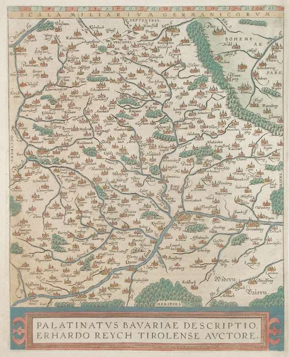
Palatinatus Bavariae Descriptio, Erhardo Reych Tirolense Auctore
€345.00
Prices incl. VAT plus shipping costs
This item is sold. Please contact us if you are searching for this item.
Eigenschaften
- Published: Platin , Antwerp
- Published date: 1584
- Type: Antique Map, map
- Technique: Copper engraving / later handcolor
- Issue date: 1584/98
- Category: Oberpfalz
- Size: 304 by 238mm (12 by 9 inches).
- Bibliography: Broe. 112.
- Stock number: 17535
- Condition: In excellent condition.
Article description
Article description
Copper, engraving decorative handcolored in wash and outline, published in the Theatrum Orbis Terrarum by Abraham Ortelius. At the bottom the colored title cartouche. Decorative and fine map of the Palatinatus Bavariae around 1584-1612. The maps shows upper Bavaria with the neighboring Bohemia woods, the Fichtelgebirge and Nürnberg. In the south the course of the Danube. The cartographic source for this map received Ortelius from Erhard Reych. The cities and town on the map still shown as miniature views in form of silhuetes. This version with the cartouche at the bottom was published 1584 for the first time. Kupferstichkarte, in dekorativem Flächenkolorit, erschienen im Theatrum Orbis Terrarum von A. Ortelius bei Juan Baptist Vrients. Im Unterrand mit ausgemalter Rollwerkskartusche. Dekorative und schöne Karte der Oberpfalz um 1584/1612.Zeigt die Oberpfalz mit angrenzendem Böhmerwald, Fichtelgebirge u. Nürnberg. Im Süden noch mit dem Lauf der Donau. Ortelius übernahm die Karte nach der Zeichnung von Erhard Reych. Die Orte noch in Silhouettenform als Miniaturansichten dargestellt. Tadelloses Exemplar. Erschien erstmals ab 1584 in dieser Variante mit der Titelkartusche im Unterrand.Broe. 112.
You might also be interested in the following products
 Mindelheim.
 Hand-Colored Original Copperplate Engraving by Johann Baptist Homann, depicting Mindelheim.. Published Nürnberg,...
€475.00
 Augspurg mit...
 Hand-Colored Original Copperplate Engraving by Christoph Weigel, depicting Augspurg mit umliegender Gegend und dabey...
€195.00
 Circulus...
 Hand-Colored Original Copperplate Engraving by Christoph Weigel, depicting Circulus Franconicus ad Occidentem vergens...
€195.00
 Oberbayern
 Hand-Colored Original Copperplate Engraving by Johann Baptist Homann, depicting Oberbayern. Published Nürnberg,...
€295.00
Recently viewed products