Ortelius, Abraham
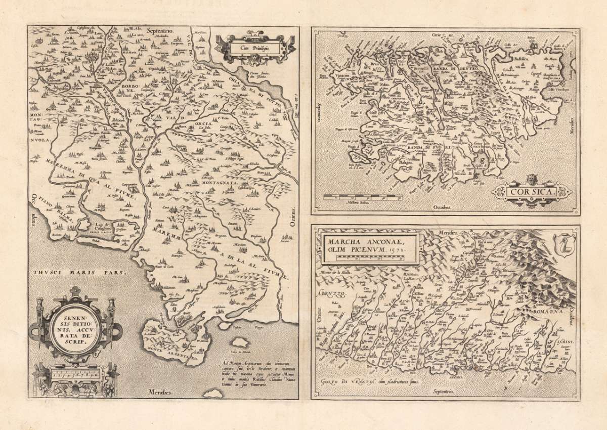
Senensis ditionis accurata descriptio - Corsica - Marcha anconae, olim picenum
Eigenschaften
- Published: Platin , Antwerp
- Published date: 1574
- Type: Antique Map, map
- Technique: Copper engraving / Uncolored
- Issue date: 1574/75
- Category: Sienna, Corsica & Ancona
- Size: 327 by 487mm (12 by 19 inches).
- Bibliography: Broe. 137 a/b/c
- Stock number: 23529
- Condition: In very good to excellent condition. Only one small marginal repaired tear at the bottom, not affecting the image. 327 by 487mm (12 by 19 inches).
Article description
Article description
Original copper engraving, uncolored as published 1574/75 in a Latin text edition of the "Theatrum Orbis Terrarum". Three maps on one plate. All maps show small title cartouches. Very nice antique copper engraved map of Corsica, parts of Tuscany around Siena and the Ancona region by Abraham Ortelius. The left map shows Tuscany, an additional small cartouche with the "privilegium". Villages and towns are shown as miniature views. The upper right map shows Corsica and the lower one shows the area around Ancona. Ortelius was born on 14 April 1527 in the city of Antwerp, which was then in the Habsburg Netherlands (modern-day Belgium). The Orthellius family were originally from Augsburg, a Free imperial city of the Holy Roman Empire. In 1535, the family had fallen under suspicion of Protestantism. Following the death of Ortelius's father, his uncle Jacobus van Meteren returned from religious exile in England to take care of Ortelius. Abraham remained close to his cousin Emanuel van Meteren, who would later move to London. In 1575 he was appointed geographer to the king of Spain, Philip II, on the recommendation of Arias Montanus, who vouched for his orthodoxy. He travelled extensively in Europe and is specifically known to have traveled throughout the Seventeen Provinces; in southern, western, northern, and eastern Germany (e.g., 1560, 1575–1576); France (1559–1560); England and Ireland (1576); and Italy (1578, and perhaps twice or thrice between 1550 and 1558). Beginning as a map-engraver, in 1547 he entered the Antwerp Guild of Saint Luke as an illuminator of maps. He supplemented his income trading in books, prints, and maps, and his journeys included yearly visits to the Frankfurt book and print fair, where he met Gerardus Mercator in 1554. In 1560, however, when travelling with Mercator to Trier, Lorraine, and Poitiers, he seems to have been attracted, largely by Mercator's influence, towards the career of a scientific geographer. (Wikipedia)Broe. 137 a/b/c
You might also be interested in the following products
 Gray's New...
 Original antique hand colored lithograph. Detailed map, colored by counties and showing townships, towns, villages,...
€65.00

 Pas-Caart van de...
 Original copper engraving, finely later hand colored in ouline and wash. Remarkable the highly decorated handcolored...
€1,100.00
 Latium. Ex...
 Original antique copper engraving, published 1612 in the famous historical Atlas "Parergon" (Latin...
€495.00
Recently viewed products