Santini, Francois and Remondini, M.
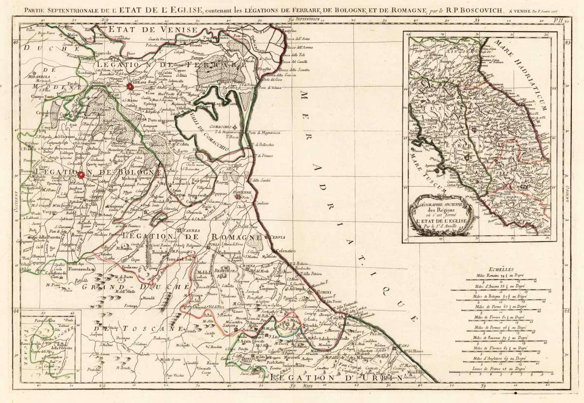
Partie Septentrionale de L´Etat de L' Eglise, contenant les Légations de Ferrare, de Bologne, et de Romagne, par...
Santini, Francois – Rome & Latium · Copper Engraving, Hand Colored · published Venice · 1776
Eigenschaften
- Published: Santini Chez M. Remondini , Venice
- Published date: 1776
- Technique: Copper engraving / Original color.
- Type: Antique Map, map
- Issue date: 1776
- Category: Bologna and Emilia-Romagna, Emilia-Romagna and Bologna
- Size: 490 by 690mm (19 by 27 inches).
- Stock number: 27294
- Condition: In excellent condition.
Article description
Article description
Original antique hand-colored copper engraving, published 1776. Depicting Rome & Latium, this map is a fine example of 0s European cartography. Image: 490 by 690mm (19 by 27 inches). An attractive and historically significant 18th-century map for the discerning collector. Francois Santini and the Remondini firm of Bassano del Grappa were leading Italian cartographic publishers of the 18th century. The Remondini family operated one of the largest and most successful printing businesses in 18th-century Italy, publishing maps, prints, books, and popular engravings across Europe. Their cartographic output frequently drew on the best French and Dutch sources, updated for an Italian audience. Maps from the Remondini/Santini collaboration are among the most important Italian cartographic productions of the Enlightenment period. A highly detailed map of the regions Ferrara, Bologna and Romagnola. The map depicts the coast on the Adriatic Sea from Fano, south of Rimini towards Ravenna towards the neighbouring state of Venice. It reaches also Bologna and includes an inset map of the state of church (Etat de L' Eglise). The old map is rich equipped with place names, castles, monasteries, mountains, lakes and rivers. Between major places are further streets engraved. The map first appeared in Santini's Atlas Universel in 1776-79 in Paris. In 1784 Santini sold the plates of the maps to M. Remondini, who published then these maps in Venice with his additional imprint in the title cartouches. A fine example from published Venice, sought after by collectors of antique maps of Italy, antique maps of Rome, and antique hand-colored copper engravings for sale. In good condition consistent with age. The map first appeared in Santini's Atlas Universel in 1776-79 in Paris. In 1784 Santini sold the plates of the maps to M. Remondini, who published then these maps in Venice with his additional imprint in the title cartouches.Santini, Francois – Rome & Latium · Copper Engraving, Hand Colored · published Venice · 1776
You might also be interested in the following products
 Pedemontanae...
 Original antique copper engraving, uncolored, from the 'Theatrum Orbis Terrarum' by Abraham Ortelius, the...
€650.00
 Naples & Sicily
 Original antique lithograph, published 1852. Depicting Kingdom of Naples, this map is a fine example of 0s European...
€145.00
 Milane States
 Original antique hand-colored lithograph, published 1852. Depicting Milan & Lombardy, this map is a fine example...
€140.00
 Les Environs De...
 Original antique hand-colored copper engraving, published 1700. Depicting Kingdom of Naples, this map is a fine...
€170.00
Recently viewed products