The following products have been found matching your search "route": 50
No results were found for the filter!
 Süd Carolina. Nach des Gouverneurs von Carolina, J. Drayton´s Charte (1803) reduciert.
 Copper engraving, uncolored as published. This interesting antique map shows South Carolina and its cartographic...
€245.00
 (West Canada, Lake Huron & Lake Ontario)
 Lithograph, original color in outline and wash. This decorative map shows the region from West Canada, Ottawa River...
€245.00
 (Illinois, Indiana and Ohio)
 Lithograph, original color in outline and wash. This decorative map shows Illinois, Indiana and a part of Ohio....
€295.00
 Tractus Rheni et Mosae, totusq, Vahallis á Rhenoberca Gorcomium usque cum terris adjacentibus ducatus Cliviae regno...
 Original antique copper engraving, hand colored in outline published in Joan Blaeu's 'Atlas Novus'....
€500.00
 Comitatus Hollandiae Tabula Pluribus Locis Recens Emendata A Frederico de Wit.
 Copper engraving, hand colored in outline and wash. A highly decorative map of Holland titled ,Comitatus Hollandiae...
€645.00
![General Karte von einem Antique General Karte von einem Theil des Russischen Reichs in Gouvernement s und Kreise eingetheilet, worauf die Post- und andere Hauptstrassen angezeigt sind bey Sr. Russisch Kayserlichen Majestaet Karten Depot im Jahre 1799 entworffen und gestochen. [folded map on linen] Aus dem russischen übersetzt, die Gouvernements Grentzen nach den Kayserlichen Ukasen vom October 1801 u: Mertz 1802 u: abgeändert, die Schiffbarkeit der Flüsse und ihre Vereinigungs Canäle zwischen den Weissen, Baltischen, Schwartze](https://bergbook.com/media/image/8a/ec/db/23098_500x500.jpg) General Karte von einem Theil des Russischen Reichs in Gouvernement s und Kreise eingetheilet, worauf die Post- und...
General Karte von einem Theil des Russischen Reichs in Gouvernement s und Kreise eingetheilet, worauf die Post- und... Copper engraving, hand colored in outline when published. Large folding map dissected on linen in four sheets, to...
€550.00
 Polynesien und der grosse Ocean im Maassstabe von 1:40.000.000. (Östliches Blatt) Von A. Petermann.
 Original lithograph, hand colored in outline and wash when published. Detailed map showing the Pacific with the...
€68.00
 Das Gebiet der Schneeberge Kilima-Ndscharo und Kenia in Ost-Afrika.
 Lithograph, original hand colored in outline when published. A detailed map of the area of the ,snow mountain...
€80.00
 Neueste Karte von Missouri. Nach den besten Quellen verbessert.
 Steel engraving, hand colored in outline. This very detailed antique map shows Missouri with the surounding. In the...
€195.00
 Das Deutsche Reich und seine Nachbarländer. Zur Übersicht der Eisenbahnen und Dampfschiffahrten.
 Steel engraving, hand colored in outline when published. This detailed antique map shows Germany with its...
€65.00
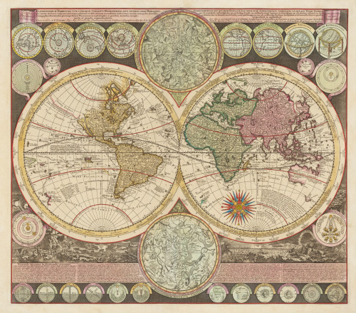
 Planisphaerium Terrestre cum Utroque Coelesti Hemisphaerio, Sive Diversa Terraquei.
 Copper engraving, hand colored in outline and wash when published. Adam Friedrich Zürner produced this interesting...
€3,500.00
 Plan-Phare Paris
 Original lithograph, printed in colors. Published in the ,Deutsche Verlagsgesellschaft' in Hamburg. Detailed...
€125.00

