Petermann, A.
Der Östliche Theil Von Nord-Amerika Zur Übersicht der Eisenbahnen & Wasserstrassen Von A. Petermann.
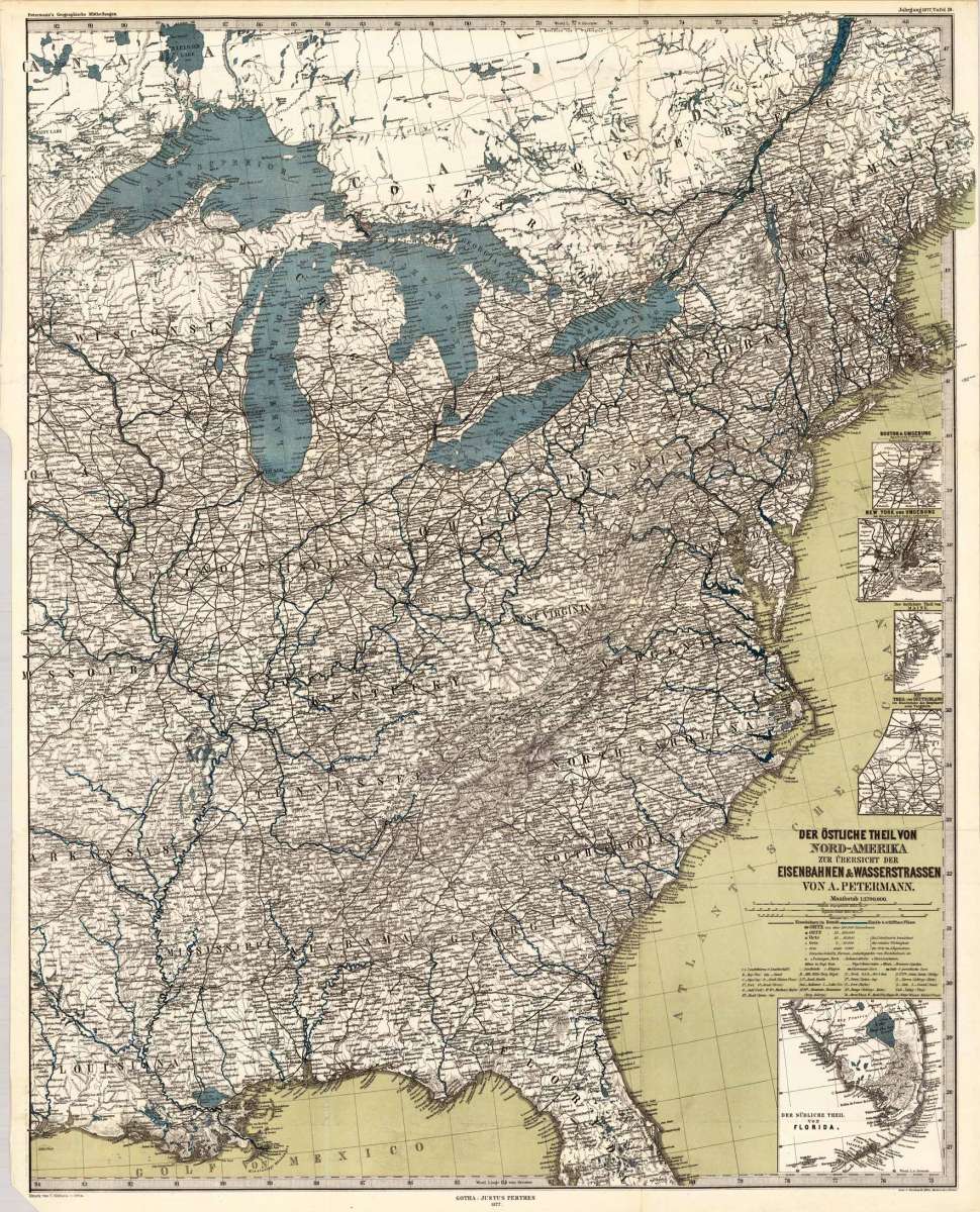
Petermann, A. – Eastern North America · Lithograph, Hand Coloured · Petermanns Geographische Mitteilungen, Gotha · 1877
Eigenschaften
- Published: Justus Perthes , Gotha
- Published date: 1877
- Type: Antique Map, map
- Technique: Lithograph / Original color.
- Issue date: 1877
- Category: Eastcoast United States
- Size: 670 by 530mm (26½ by 20¾ inches).
- Stock number: 17033
- Condition: In excellent condition. The map was originally published folded, so that the old folds are still slightly visible. 670 by 530mm (26½ by 20¾ inches).
Article description
Article description
Original antique lithograph, hand coloured, published by Justus Perthes in Gotha for 'Petermanns Geographische Mitteilungen', 1877. Original lithograph, handcolored in outline and printed in colors. Sheet: 670 by 530mm (26½ by 20¾ inches).. August Heinrich Petermann (1822–1878) was one of the most important German cartographers and geographers of the 19th century. Born in Bleicherode, Saxony, he trained at the Geographische Kunstschule in Potsdam under Heinrich Berghaus — himself a leading student of Alexander von Humboldt. After a formative decade in Edinburgh and London (1845–1854), where he gained broad experience in the commercial and scientific aspects of cartography, Petermann returned to Gotha and joined the Justus Perthes publishing house. In 1855 he founded 'Petermanns Geographische Mitteilungen' (PGM), which swiftly became one of the world's foremost geographical journals — the definitive record of the great age of exploration and discovery. Petermann personally produced over 500 maps and signed 226 articles in PGM, ranging across Africa, the Polar regions, Asia, and the history and practice of cartography. In 1902, the eminent British cartographer J. G. Bartholomew wrote: 'No one has done more than he to advance modern cartography.' His maps are held in major institutions worldwide, including the Library of Congress, the British Library, and the Bibliothèque nationale de France. Large and detailed map showing the eastern part of the United States with its railroads and water streets. The map provides a huge amount of information (bays, canals, forts, gulfs, lakes, hills, Sierras, Indians, etc.), as well several inset maps (Boston, New York and Maine) and one inset map of the southern part of Florida. In excellent condition. The map was originally published folded, so that the old folds are still slightly visible.Petermann, A. – Eastern North America · Lithograph, Hand Coloured · Petermanns Geographische Mitteilungen, Gotha · 1877
You might also be interested in the following products
 Delaware and...
 Lithograph, color by Johnson & Ward, published 1862 by Johnson & Ward, New York. Image size: 400 by 320mm (15...
€90.00
 Vereinigte...
 Lithograph, hand-colored in outline by Bromme, Traugott, published 1855 by Hoffm.Verlagsbuchhandlung, Stuttgart....
€80.00
 (Vermont - New...
 Lithograph, hand-colored in outline by Smith, J. Calvin, published 1845 by Th. Fischer, Cassel. Image size: 370 by...
€295.00
 Gray's New...
 Lithograph, original color in outline by Gray, Frank, published 1884 by O.W. Gray & Son, Philadelphia. Image...
€95.00
Recently viewed products