Johnson & Browning
Johnson's New Hampshire and Vermont by Johnson & Browning.
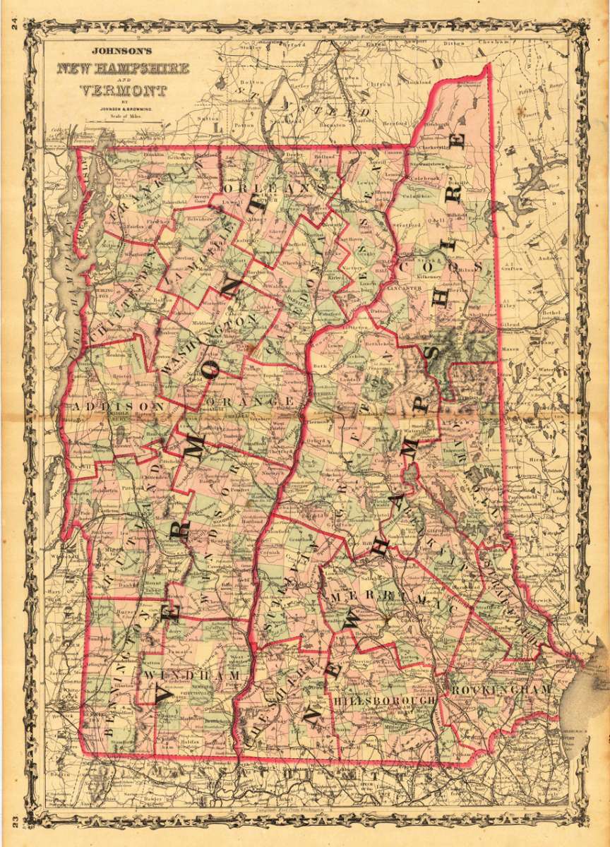
Johnson & Browning – Johnson's New Hampshire and Vermont by Johnson & Browni... · Antique Map, Lithograph · 608 x 425mm · Johnson & Ward, New York 1868
Eigenschaften
- Published: Johnson & Ward , New York
- Published date: 1868
- Type: Antique Map, map
- Technique: Lithograph / Original color.
- Issue date: 1868
- Category: New Hampshire & Vermont
- Size: 608 by 425mm (24 by 16 inches).
- Stock number: 19655
- Condition: In excellent condition.
Article description
Article description
Lithograph, original color in outline by Johnson & Browning, published 1868 by Johnson & Ward, New York. Image size: 608 by 425mm (24 by 16 inches). From Johnson's New Illustrated Family Atlas — the leading American atlas of the Civil War era. A.J. Johnson (Alvin Jewett Johnson, 1827–1884) launched his celebrated atlas series after acquiring Colton's plates in 1860, initially publishing as Johnson & Browning before reorganizing as Johnson & Ward in 1863. Johnson's New Illustrated Family Atlas became the dominant American commercial atlas of the Civil War era, offering detailed steel-engraved state and regional maps with vivid hand-applied outline coloring. These atlases were sold by subscription and reached a vast American audience, making them among the most widely distributed — and today most collectible — American maps of the 19th century. This antique map shows the states New Hampshire and Vermont. The map is very detailed engraved with many place names, rivers, streets etc. A decorative large scale map of New Hampshire & Vermont, decorated with an ornated border around the map. In excellent condition.Johnson & Browning – Johnson's New Hampshire and Vermont by Johnson & Browni... · Antique Map, Lithograph · 608 x 425mm · Johnson & Ward, New York 1868
You might also be interested in the following products
 Delaware and...
 Lithograph, color by Johnson & Ward, published 1862 by Johnson & Ward, New York. Image size: 400 by 320mm (15...
€90.00
 Vereinigte...
 Lithograph, hand-colored in outline by Bromme, Traugott, published 1855 by Hoffm.Verlagsbuchhandlung, Stuttgart....
€80.00
 (Vermont - New...
 Lithograph, hand-colored in outline by Smith, J. Calvin, published 1845 by Th. Fischer, Cassel. Image size: 370 by...
€295.00
 Gray's New...
 Lithograph, original color in outline by Gray, Frank, published 1884 by O.W. Gray & Son, Philadelphia. Image...
€95.00
Recently viewed products