Vandermaelen, Phillippe Marie
Amer.Sep. Partie des Etats-Unis. No 43.
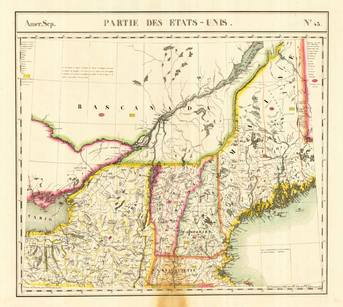
Vandermaelen, Phillippe Marie – Amer.Sep. Partie des Etats-Unis. No 43 · Antique Map, Lithograph · 458 x 505mm · Brussels 1825
Eigenschaften
- Published: Brussels
- Published date: 1825
- Type: Antique Map, map
- Issue date: 1825
- Technique: Lithograph / Original color.
- Category: New England
- Size: 458 by 505mm (18 by 20 inches).
- Stock number: 19660
- Condition: Still in very good to excellent condition. Slightly browned at the lower centre fold, affecting mostly the blank margin. Hardly visible within the image. 458 by 505mm (18 by 20 inches).
Article description
Article description
Lithograph, hand-colored in outline by Vandermaelen, Phillippe Marie, published 1825 by Brussels. Image size: 458 by 505mm (18 by 20 inches). A rare example from Vandermaelen's landmark Atlas universel — the first lithographic world atlas. Philippe Marie Guillaume Vandermaelen (1795–1869) was a pioneering Flemish cartographer and geographer, often called the 'Mercator of young Belgium'. Working from Brussels, he produced the groundbreaking Atlas universel (1825–1827), the first world atlas printed by lithography and the first to depict the entire globe at a single uniform scale. The atlas comprised six volumes with approximately 390 maps, representing a revolution in cartographic publishing. In 1830 Vandermaelen founded the Établissement géographique de Bruxelles, which housed Belgium's first lithographic press dedicated to cartography alongside a public library and ethnographic museum. His North American maps from the Atlas universel are prized by collectors for their accuracy, delicate lithographic detail, and their historic role as the first such images of the continent produced by the lithographic process. Large and detailed map showing the Eastern Seaboard from Duxbury, CT. across Massachusetts, New Hampshire towards Columbia near Pleasant River in northern Maine. Inland the map extends towards the state of New York with Lake Ontario. Equipped with detailed information on the names of rivers and lakes, mountains, Forts and Indian tribes. Still in very good to excellent condition. Slightly browned at the lower centre fold, affecting mostly the blank margin. Hardly visible within the image.Vandermaelen, Phillippe Marie – Amer.Sep. Partie des Etats-Unis. No 43 · Antique Map, Lithograph · 458 x 505mm · Brussels 1825
You might also be interested in the following products
 Delaware and...
 Lithograph, color by Johnson & Ward, published 1862 by Johnson & Ward, New York. Image size: 400 by 320mm (15...
€90.00
 Vereinigte...
 Lithograph, hand-colored in outline by Bromme, Traugott, published 1855 by Hoffm.Verlagsbuchhandlung, Stuttgart....
€80.00
 (Vermont - New...
 Lithograph, hand-colored in outline by Smith, J. Calvin, published 1845 by Th. Fischer, Cassel. Image size: 370 by...
€295.00
 Gray's New...
 Lithograph, original color in outline by Gray, Frank, published 1884 by O.W. Gray & Son, Philadelphia. Image...
€95.00
Recently viewed products