Meyer, Joseph
Neueste Karte von New York mit seinen Canaelen, Strassen, Eisenbahnen, Entfernungen der Hauptpunkte und Routen für...
Meyer, Joseph – Neueste Karte von New York mit seinen Canaelen, Strasse... · Antique Map, Steel Engraving · 300 x 371mm · Bibliograph. Institut, Hildburghaus...
Eigenschaften
- Published: Bibliograph. Institut , Hildburghausen
- Published date: 1844
- Type: Antique Map, map
- Technique: Steel engraving, original color
- Category: New York State
- Issue date: 1844
- Size: 300 by 371mm (11 by 14 inches).
- Stock number: 19674
- Condition: In excellent condition. 300 by 371mm (11 by 14 inches).
Article description
Article description
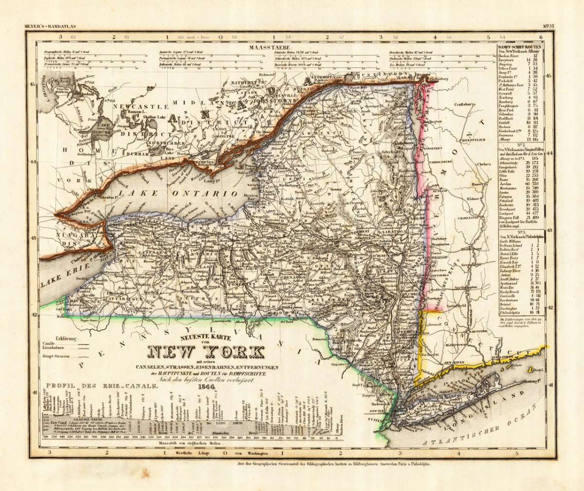
Steel Engraving, hand-colored in outline by Meyer, Joseph, published 1844 by Bibliograph. Institut, Hildburghausen. Image size: 300 by 371mm (11 by 14 inches). From Meyer's acclaimed steel-engraved atlas, one of the finest German cartographic productions of the 19th century. Joseph Meyer (1796–1856) was one of the most prolific and influential German publishers of the 19th century. Born in Gotha, he founded the Bibliographisches Institut, which he moved to Hildburghausen in 1828, and built it into a leading European publishing house. Meyer produced numerous finely engraved atlases, including the celebrated Meyer's Groẞer Hand-Atlas (1843–1860), engraved with exceptional precision on steel plates by his talented team of cartographers including Carl Radefeld. His maps of North American states from the 1840s and 1850s are based on the best available American sources of the period, including Tanner's surveys, and offer a detailed German perspective on the rapidly expanding United States. Meyer's steel engravings, often hand-colored in outline, are treasured by collectors for their technical perfection and historical accuracy. Detailed engraved antique map of the state of New York. Inside the map are many place names, rivers, lakes, streets, etc. The map is equipped with with a table of steamship routes (New York to Albany - New York to the Niagara Falls - New York to Philadelphia) and a profile of the Erie Channel. At the top we find mileage scales. Lake Erie and Lake Ontario are shown on the map. In excellent condition.Meyer, Joseph – Neueste Karte von New York mit seinen Canaelen, Strasse... · Antique Map, Steel Engraving · 300 x 371mm · Bibliograph. Institut, Hildburghaus...
You might also be interested in the following products
 Delaware and...
 Lithograph, color by Johnson & Ward, published 1862 by Johnson & Ward, New York. Image size: 400 by 320mm (15...
€90.00
 Vereinigte...
 Lithograph, hand-colored in outline by Bromme, Traugott, published 1855 by Hoffm.Verlagsbuchhandlung, Stuttgart....
€80.00
 (Vermont - New...
 Lithograph, hand-colored in outline by Smith, J. Calvin, published 1845 by Th. Fischer, Cassel. Image size: 370 by...
€295.00
 Gray's New...
 Lithograph, original color in outline by Gray, Frank, published 1884 by O.W. Gray & Son, Philadelphia. Image...
€95.00
Recently viewed products