Johnson & Browning
Annandale - Tivoli - Barrytown - Madalin - Upper Red Hook
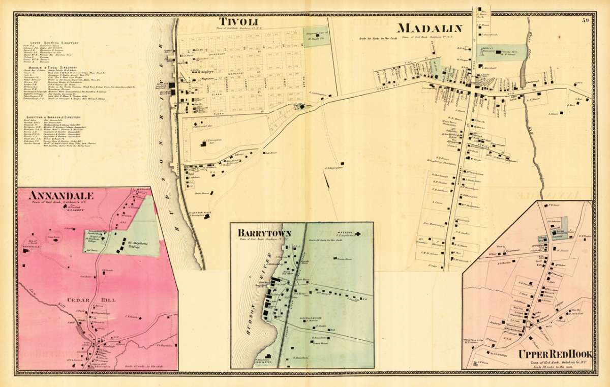
Johnson & Browning – Annandale - Tivoli - Barrytown - Madalin - Upper Red Ho... · Antique Map, Lithograph · 392 x 630mm · New York 1859
Eigenschaften
- Published: New York
- Published date: 1859
- Type: Antique Map, map
- Technique: Lithograph / Original color.
- Issue date: 1859
- Category: Greater New York
- Size: 392 by 630mm (15 by 24 inches).
- Stock number: 19675
- Condition: In very good condition. A few minor margin mended splits, not affecting the map. 392 by 630mm (15 by 24 inches).
Article description
Article description
Lithograph, original color in outline by Johnson & Browning, published 1859 by New York. Image size: 392 by 630mm (15 by 24 inches). From Johnson's New Illustrated Family Atlas — the leading American atlas of the Civil War era. A.J. Johnson (Alvin Jewett Johnson, 1827–1884) launched his celebrated atlas series after acquiring Colton's plates in 1860, initially publishing as Johnson & Browning before reorganizing as Johnson & Ward in 1863. Johnson's New Illustrated Family Atlas became the dominant American commercial atlas of the Civil War era, offering detailed steel-engraved state and regional maps with vivid hand-applied outline coloring. These atlases were sold by subscription and reached a vast American audience, making them among the most widely distributed — and today most collectible — American maps of the 19th century. This antique map shows five towns (Annandale, Barrytown, Upper Red Hook, Madalin and Tivoli) from of boroughs of New York with their city centers, main streets. Certain buildings or possessions are marked. In very good condition. A few minor margin mended splits, not affecting the map.Johnson & Browning – Annandale - Tivoli - Barrytown - Madalin - Upper Red Ho... · Antique Map, Lithograph · 392 x 630mm · New York 1859
You might also be interested in the following products
 Delaware and...
 Lithograph, color by Johnson & Ward, published 1862 by Johnson & Ward, New York. Image size: 400 by 320mm (15...
€90.00
 Vereinigte...
 Lithograph, hand-colored in outline by Bromme, Traugott, published 1855 by Hoffm.Verlagsbuchhandlung, Stuttgart....
€80.00
 (Vermont - New...
 Lithograph, hand-colored in outline by Smith, J. Calvin, published 1845 by Th. Fischer, Cassel. Image size: 370 by...
€295.00
 Gray's New...
 Lithograph, original color in outline by Gray, Frank, published 1884 by O.W. Gray & Son, Philadelphia. Image...
€95.00
Recently viewed products