SDUK (Society for the diffusion of useful knowledge)
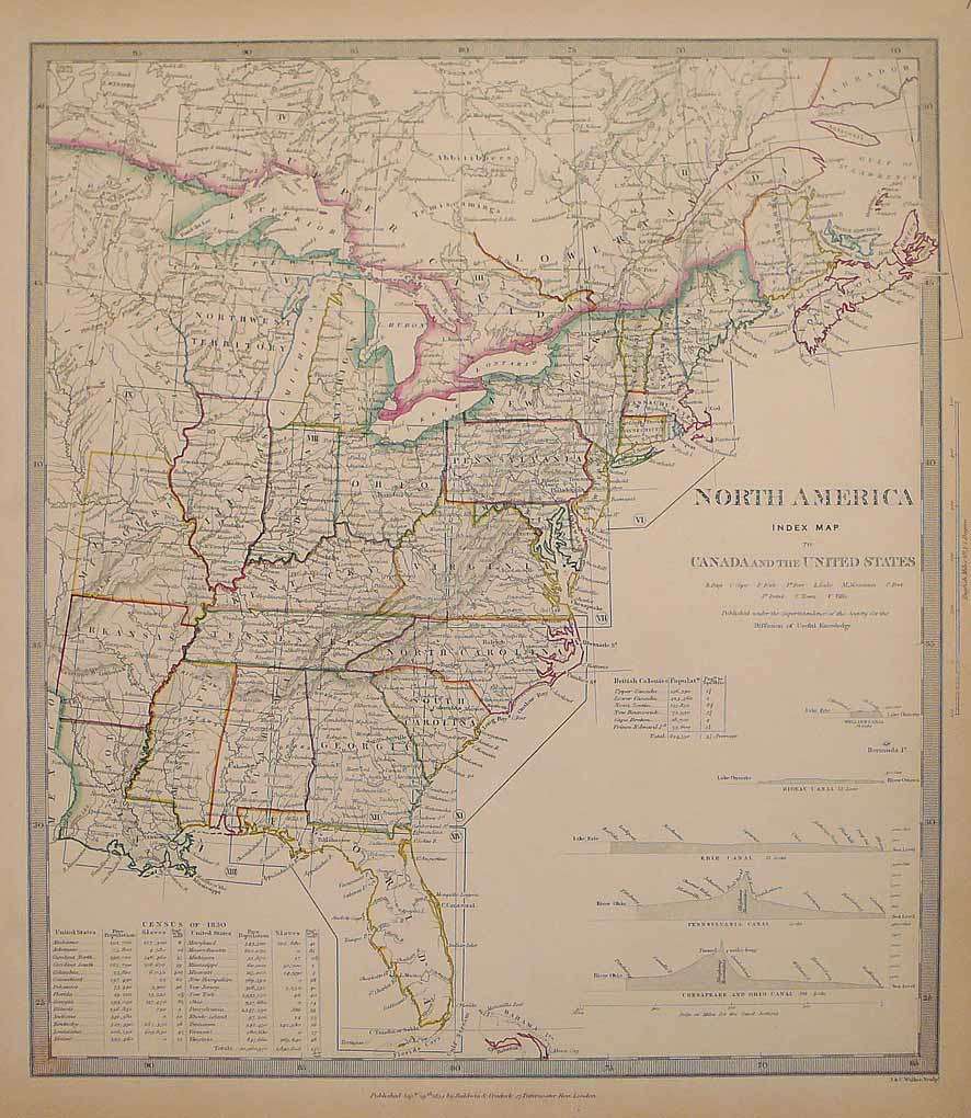
North America Index Map to Canada and the United States
SDUK (Society for the diffusion of useful knowledge) – North America Index Map to Canada and the United States · Antique Map, Steel Engraving · 362 x 318mm ·...
Eigenschaften
- Published: London
- Published date: 1834
- Technique: Steel engraving, original color
- Issue date: 1834
- Type: map
- Category: Canada & the United States
- Size: 362 by 318mm (14 by 12 inches).
- Stock number: 21353
- Condition: In excellent condition. 362 by 318mm (14 by 12 inches).
Article description
Article description
Steel Engraving, hand-colored in outline by SDUK (Society for the diffusion of useful knowledge), published 1834 by Baldwin & Cradock, London. Image size: 362 by 318mm (14 by 12 inches). From the celebrated SDUK series — widely regarded as among the finest steel-engraved maps of the 19th century. The Society for the Diffusion of Useful Knowledge (SDUK) was a Whig organization founded in London in 1826 with the admirable goal of making information accessible to the working and middle classes. Its map committee began publishing in 1829, producing a celebrated series of finely engraved steel maps initially under the Baldwin & Cradock imprint, later reissued by Chapman & Hall (from 1844) and Charles Knight. The SDUK maps are renowned for their exceptional precision, elegant typography, and fine steel engraving — widely considered among the finest examples of British cartography from the first half of the 19th century. Their North American sheets were produced at a transformative moment in the continent's history, making them invaluable historical documents as well as beautiful collector objects. This North America map shows the East coast from Labrador to Florida and the Bahamas. The individual states are painted beautifully in outline color. The title is engraved in the middle of the right side of the map, above a table of the British colonies and the sea levels of the Welland Canal, the Rideau Canal, the Erie Canal, the Pennsylvania Canal, Chesapeake and Ohio Canal. In the lower left corner is a table of the free Population and the Slaves around 1830 in America. In excellent condition. 362 by 318mm (14 by 12 inches).SDUK (Society for the diffusion of useful knowledge) – North America Index Map to Canada and the United States · Antique Map, Steel Engraving · 362 x 318mm ·...
You might also be interested in the following products
 Delaware and...
 Lithograph, color by Johnson & Ward, published 1862 by Johnson & Ward, New York. Image size: 400 by 320mm (15...
€90.00
 Vereinigte...
 Lithograph, hand-colored in outline by Bromme, Traugott, published 1855 by Hoffm.Verlagsbuchhandlung, Stuttgart....
€80.00
 (Vermont - New...
 Lithograph, hand-colored in outline by Smith, J. Calvin, published 1845 by Th. Fischer, Cassel. Image size: 370 by...
€295.00
 Gray's New...
 Lithograph, original color in outline by Gray, Frank, published 1884 by O.W. Gray & Son, Philadelphia. Image...
€95.00
Recently viewed products