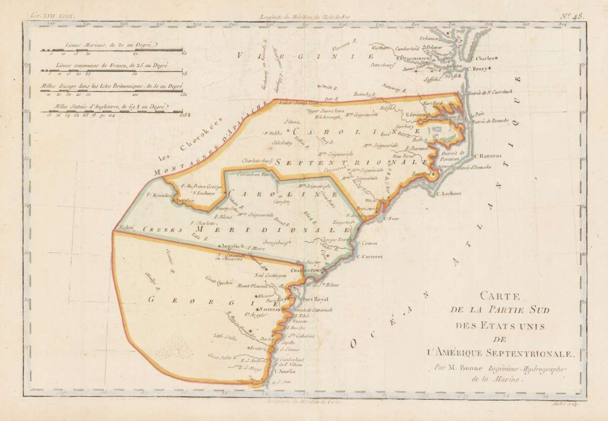
Bonne, Rigobert
Carte de la Partie Sud des Etats Unis de L'Amerique Septentrionale. Par M. Bonne, Ingénieur-Hydrographe de la...
Bonne, Rigobert – Carte de la Partie Sud des Etats Unis de L'Amerique Sep... · Antique Map, Copper Engraving · 213 x 320mm · M. Bonne, Paris 1780
Eigenschaften
- Published: Paris
- Published date: 1780
- Type: Antique Map, map
- Technique: Copper engraving / later hand color
- Issue date: 1780
- Category: Virginia, Georgia and the Carolinas
- Size: 213 by 320mm (8 by 12 inches).
- Stock number: 31811
- Condition: In excellent condition.
Article description
Article description
Copper Engraving, hand-colored in outline by Bonne, Rigobert, published 1780 by M. Bonne, Paris. Image size: 213 by 320mm (8 by 12 inches). By France's Royal Cartographer — a fine example of late Enlightenment scientific cartography. Rigobert Bonne (1727–1794) was one of the most important French cartographers of the late 18th century. In 1773 he succeeded the legendary Jacques-Nicolas Bellin as Royal Cartographer to France, serving as First Hydrographer of the Dépôt de Cartes et Plans de la Marine from 1775 to 1789. He drew the maps for the Abbé Raynal's Atlas de toutes les parties connues du globe terrestre (1780) and is best known for his work on the Atlas encyclopédique (1788) with Nicolas Desmarest. Bonne's cartographic style represents the transition from the decorative 17th-century tradition toward a more scientific, detail-oriented aesthetic. His maps, notable for their precision and clear hydrographic delineation, were widely reprinted throughout Europe and remain sought after by collectors of Enlightenment-era cartography. Detailed map including Virginia, Georgia and the Carolinas, published shortly after the conclusion of the American Revolution. In excellent condition.Bonne, Rigobert – Carte de la Partie Sud des Etats Unis de L'Amerique Sep... · Antique Map, Copper Engraving · 213 x 320mm · M. Bonne, Paris 1780
You might also be interested in the following products
 Delaware and...
 Lithograph, color by Johnson & Ward, published 1862 by Johnson & Ward, New York. Image size: 400 by 320mm (15...
€90.00
 Vereinigte...
 Lithograph, hand-colored in outline by Bromme, Traugott, published 1855 by Hoffm.Verlagsbuchhandlung, Stuttgart....
€80.00
 (Vermont - New...
 Lithograph, hand-colored in outline by Smith, J. Calvin, published 1845 by Th. Fischer, Cassel. Image size: 370 by...
€295.00
 Gray's New...
 Lithograph, original color in outline by Gray, Frank, published 1884 by O.W. Gray & Son, Philadelphia. Image...
€95.00
Recently viewed products