Beers, Frederick W.
Fishkill on the Matteawan Hudson
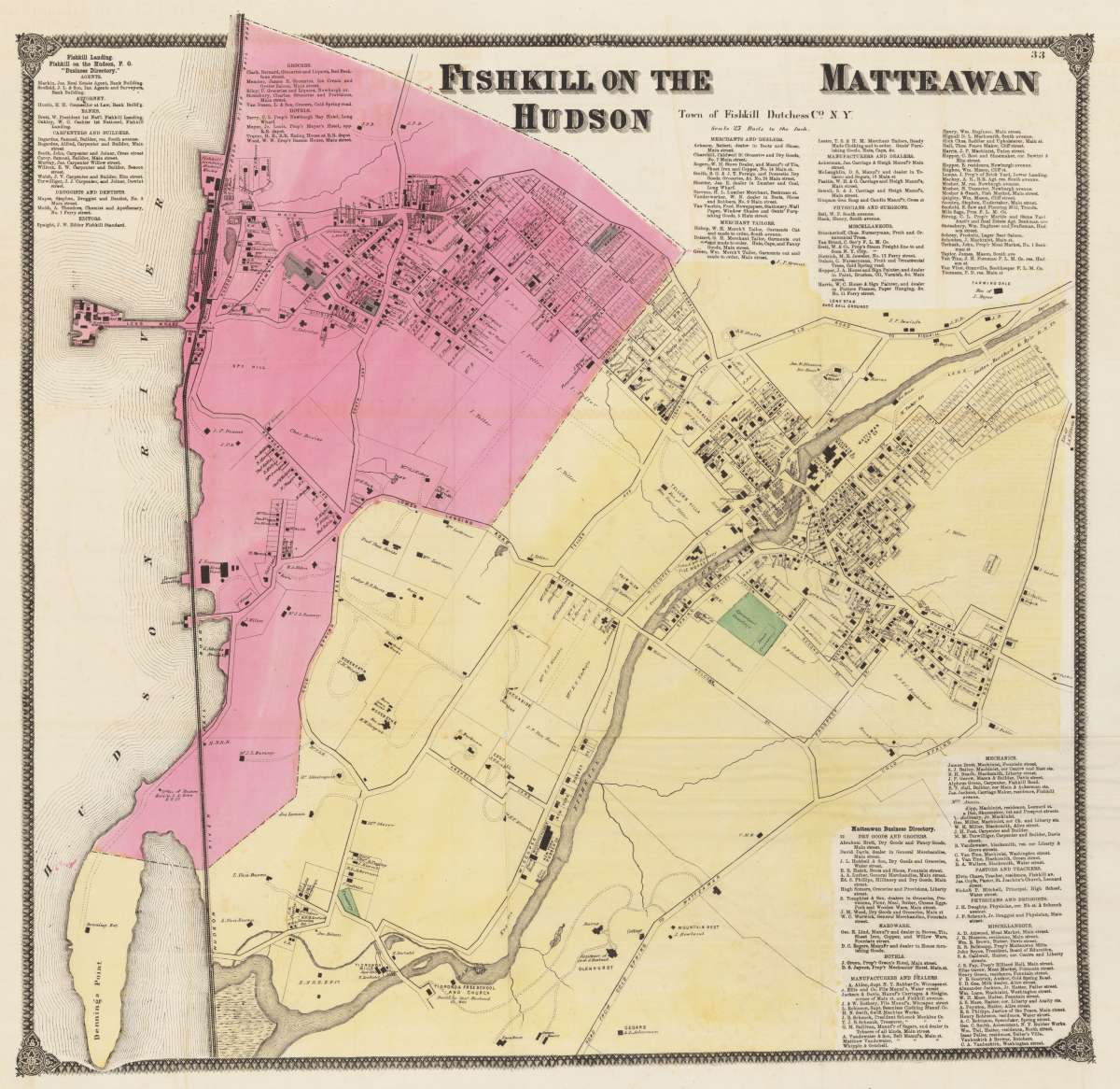
Beers, Frederick W. – Fishkill on the Matteawan Hudson · Antique Map, Lithograph · 565 x 580mm · Beers, Ellis, & Soule, New York 1860
Eigenschaften
- Published: New York
- Published date: 1860
- Technique: Lithograph / Original color.
- Issue date: 1860
- Category: New York
- Type: map
- Size: 565 by 580mm (22 by 22 inches).
- Stock number: 30492
- Condition: In excellent condition. On very thin paper.
Article description
Article description
Lithograph, original color in outline by Beers, Frederick W, published 1860 by Beers, Ellis, & Soule, New York. Image size: 565 by 580mm (22 by 22 inches). From Beers's celebrated county atlas — an irreplaceable primary record of 19th-century Hudson Valley topography. Frederick William Beers (1839–1933) was an American cartographer and publisher best known for his detailed county and regional atlases of New York State. Working from Manhattan, Beers published his Atlas of New York and Vicinity in 1867 (in collaboration with A.D. Ellis and G.G. Soule), containing 61 lithographed maps of Westchester, Dutchess, and Putnam counties and their towns. He is credited with personally surveying every county in New York State and later extended his work to Ohio, Pennsylvania, Michigan, Connecticut, and Vermont. Beers's atlas maps of the Hudson Valley constitute an irreplaceable primary record of mid-19th-century settlement, property ownership, and local topography — prized both by local historians and by collectors of American county atlases. This antique very detailed map shows the town Fishkill. The title is in the upper right corner with an overview about all dealers, hotels, hardware, physicans and druggists. In excellent condition. On very thin paper.Beers, Frederick W. – Fishkill on the Matteawan Hudson · Antique Map, Lithograph · 565 x 580mm · Beers, Ellis, & Soule, New York 1860
You might also be interested in the following products
 New York. Carte...
 Copper Engraving, hand-colored in outline by Buchon, Jean Alexandre, published 1825 by J. Carez, Paris. Image size:...
€250.00
 Johnson's New...
 Lithograph, original color in outline by Johnson & Ward, published 1865 by Johnson & Ward, New York. Image...
€50.00
 Geographisch-stat...
 Copper Engraving, hand-colored in outline by [Geographisches Institut], published 1824 by Geographisches Institut,...
€295.00
 Old Dutch Church...
 Lithograph by Beers, F.W, published 1868 by New York. Image size: 300 by 310mm (11 by 12 inches). From Beers's...
€155.00
Recently viewed products