Homann, Johann Baptist
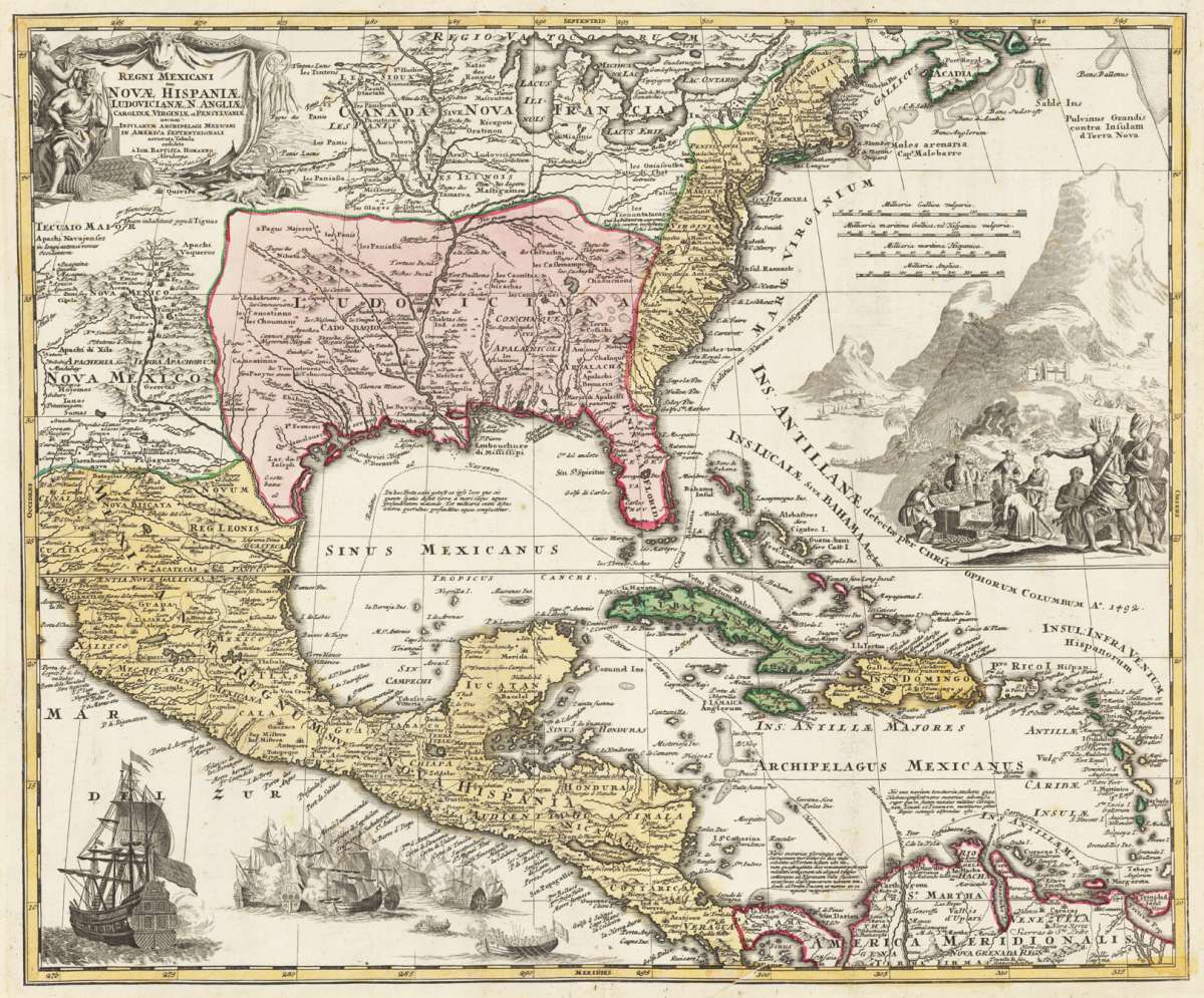
Regni Mexicani seu Novae Hispaniae Ludovicianae, N. Angliae, Carolinae, Virginiae et Pensylvaniae, nec non Insularum,...
Homann, Johann Baptist – Regni Mexicani seu Novae Hispaniae Ludovicianae, N. Ang... · Antique Map, Copper Engraving · 473 x 572mm · Homann, J. B., Nürnberg 1...
Eigenschaften
- Published: Nürnberg
- Published date: 1716
- Technique: Copper engraving / Original color.
- Issue date: 1716-20
- Category: New Mexico - Louisiana - Florida
- Type: map
- Size: 473 by 572mm (18 by 22 inches).
- Stock number: 29550
- Condition: A strong impression, overall in very good condition. 473 by 572mm (18 by 22 inches).
Article description
Article description
Copper Engraving, hand-colored in outline by Homann, Johann Baptist, published 1716-20 by Homann, J. B, Nürnberg. Image size: 473 by 572mm (18 by 22 inches). By Imperial Geographer Homann — one of the most important 18th-century maps of New Spain. Johann Baptist Homann (1664–1724) was the most important German cartographer and map publisher of the early 18th century. In 1702 he founded the Homann publishing house in Nuremberg, which became the dominant German cartographic publisher for the next century. In 1715, Holy Roman Emperor Charles VI awarded Homann the title of Imperial Geographer, confirming his preeminence. His Regni Mexicani map (c.1716–1720), based on the best available Spanish colonial sources, is one of the finest and most detailed 18th-century maps of New Spain and the Gulf Coast region, notable for its elaborate baroque cartouche and its historical documentation of the Spanish colonial presence in North America. This famous map of the Southeast of North America was published in J. B. Homann´s famous printing house in Nürnberg after the cartographic sources by G. de Isle in 1703 and is also based on the explorations by La Salle. The map is ornated with highly decorative allegories on the Spanish exploration in the West Indies and New Mexico. In the upper left corner the engraved title in the allegoric title cartouche with the engraved 'privilegium' (second state, Louisiana is now named 'Ludoviciana' instead of 'Florida' from the first state). The map itself provides a very good information on many place names, rivers, mountains and lakes. A strong impression, overall in very good condition. 473 by 572mm (18 by 22 inches).Homann, Johann Baptist – Regni Mexicani seu Novae Hispaniae Ludovicianae, N. Ang... · Antique Map, Copper Engraving · 473 x 572mm · Homann, J. B., Nürnberg 1...
You might also be interested in the following products
 Wassily...
 Erste Ausgabe. Die Texte von M. Bill, Jean Arp, Carola Giedion-Welcker, Nina Kandinsky, Alberto Magnelli, u.a....
€120.00
DLM No. 65 –... Folio. 20 unnum. SS., 2nd edition, illustrated with 14 reproduced drawings by Giacometti (3 of them printed as color...
€145.00
Die Zwille Mit Schutzumschlag und im In Orig.-Schuber. - Erstausgabe. Exemplar 108 von 200 nummerierten Exemplaren der von Ernst...
€145.00
Recently viewed products