Meyer, Joseph & Radefeld, Carl
Neueste Karte von Arkansas mit seinen Canaelen Strassen & Entfernungen der Hauptpunkte.
Meyer, Joseph & Radefeld, Carl – Neueste Karte von Arkansas mit seinen Canaelen Strassen... · Antique Map, Steel Engraving · 375 x 302mm · Meyer, Hildburghau...
Eigenschaften
- Published: Meyer , Hildburghausen
- Published date: 1851
- Type: Antique Map, map
- Technique: Steel engraving, original color
- Issue date: 1851
- Category: Arkansas
- Size: 375 by 302mm (14 by 12 inches).
- Stock number: 12112
- Condition: In excellent condition. 375 by 302mm (14 by 12 inches).
Article description
Article description
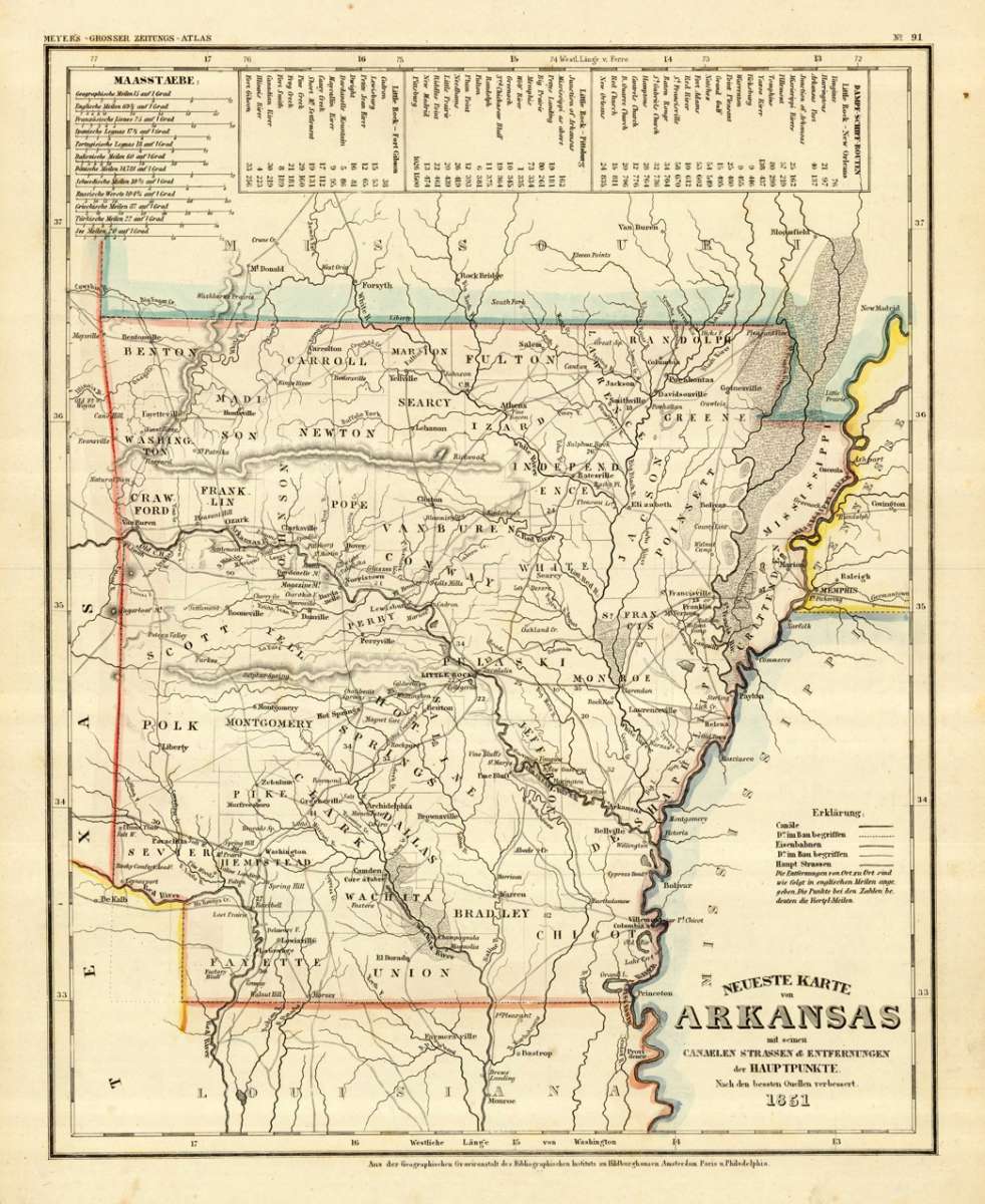
Steel Engraving, hand-colored in outline by Meyer, Joseph & Radefeld, Carl, published 1851 by Meyer, Hildburghausen. Image size: 375 by 302mm (14 by 12 inches). From Meyer's acclaimed steel-engraved atlas, one of the finest German cartographic productions of the 19th century. Joseph Meyer (1796–1856) and Carl Christian Franz Radefeld (1788–1874) formed one of the most productive cartographic partnerships in 19th-century German publishing. Working from the Bibliographisches Institut in Hildburghausen, their collaboration produced the beautifully engraved Meyer's Groẞer Hand-Atlas (1843–1860), renowned across Europe for its precision and completeness. Radefeld was a master steel engraver whose meticulous work elevated Meyer's atlases above their competitors. Their North American maps draw on the best American survey sources of the era — including Tanner's work — and represent the finest German cartographic record of mid-19th-century America. These steel engravings, typically hand-colored in outline, are prized by collectors for their quality and historical depth. This antique map shows Arkansas with his canals, streets and distances from the main points. The map is equipped with many streets, routes, rivers, lakes, place names, etc. In the upper side we find a mileage scale and steamship routes: Little Rock - Pittsburg, Little Rock - Fort Gibson & Little Rock - New Orleans. In excellent condition.Meyer, Joseph & Radefeld, Carl – Neueste Karte von Arkansas mit seinen Canaelen Strassen... · Antique Map, Steel Engraving · 375 x 302mm · Meyer, Hildburghau...
You might also be interested in the following products
 Arkansas No:9
 Lithograph, original color in outline by Smith, J. Calvin, published 1855-60 by Theodor Fischer, Kassel. Image size:...
€395.00
 Carte du Mexique,...
 Copper Engraving, hand-colored in outline by Santini, Francois and Remondini, M, published 1779-84 by M. Remondini,...
€545.00
 Regni Mexicani...
 Copper Engraving, hand-colored in outline by Homann, Johann Baptist, published 1716-20 by Homann, J. B, Nürnberg....
€1,100.00
 Amér. Sep. Partie...
 Lithograph, hand-colored in outline by Vandermaelen, Phillippe Marie, published 1825 by Phillippe Marie Vandermaelen,...
€195.00
Recently viewed products