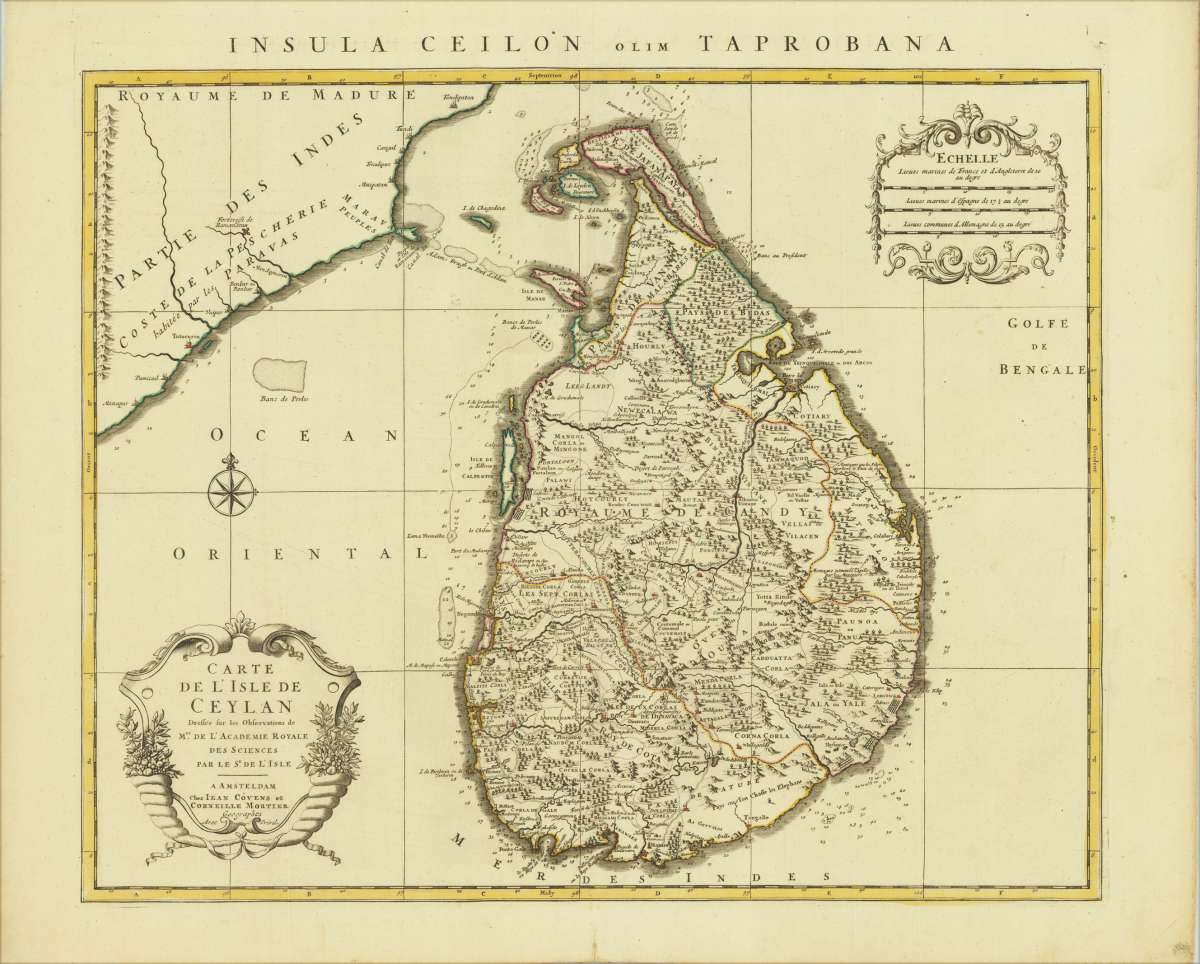
Mortier, Cornelius & Covens, Jean.
Carte De L'Isle De Ceylan dessée sur les Observations de Mrs. de L´Academie Royale des sciences par le Se. de...
Insula Ceilon olim Taprobana
Prices incl. VAT plus shipping costs
This item is sold. Please contact us if you are searching for this item.
- Published: Amsterdam
- Published date: 1742
- Technique: Copperengraving/handcolored., Copper engraving / hand colored.
- Issue date: 1742
- Type: map
- Category: Sri Lanka
- Size: 465 by 570mm (18¼ by 22½ inches).
- Bibliography: Koeman, C&M 7, #91.
- Stock number: 31413
- Condition: In excellent condition.
Article description
Original copper engraving, hand colored in outline and wash when published. Fine example of the first state of De L'Isle's map of Sri Lanka. Very detailed map, including towns, provinces, rivers, mountains, bays, harbors, islands, etc. Guillaume De L'Isle (1675-1726) is probably the greatest figure in French cartography. Having learned geography from his father Claude, by the age of eight or nine he could draw maps to demonstrate ancient history. He studied mathematics and astronomy under Cassini, from whom he received a superb grounding in scientific cartography—the hallmark of his work. His first atlas was published in ca. 1700. In 1702 he was elected a member of the Academie Royale des Sciences and in 1718 he became Premier Geographe du Roi. De L'Isle's work was important as marking a transition from the maps of the Dutch school, which were highly decorative and artistically-orientated, to a more scientific approach. He reduced the importance given to the decorative elements in maps, and emphasized the scientific base on which they were constructed. His maps of the newly explored parts of the world reflect the most up-to-date information available and did not contain fanciful detail in the absence of solid information. It can be fairly said that he was truly the father of the modern school of cartography at the commercial level. De L'Isle also played a prominent part in the recalculation of latitude and longitude, based on the most recent celestial observations. His major contribution was in collating and incorporating this latitudinal and longitudinal information in his maps, setting a new standard of accuracy, quickly followed by many of his contemporaries. Guillaume De L'Isle's work was widely copied by other mapmakers of the period, including Chatelain, Covens & Mortier, and Albrizzi.
Insula Ceilon olim Taprobana
Koeman, C&M 7, #91.