Buchon, Jean Alexandre
Caroline Meridionale. Carte Géographique, Statistique et Historique De Caroline du South
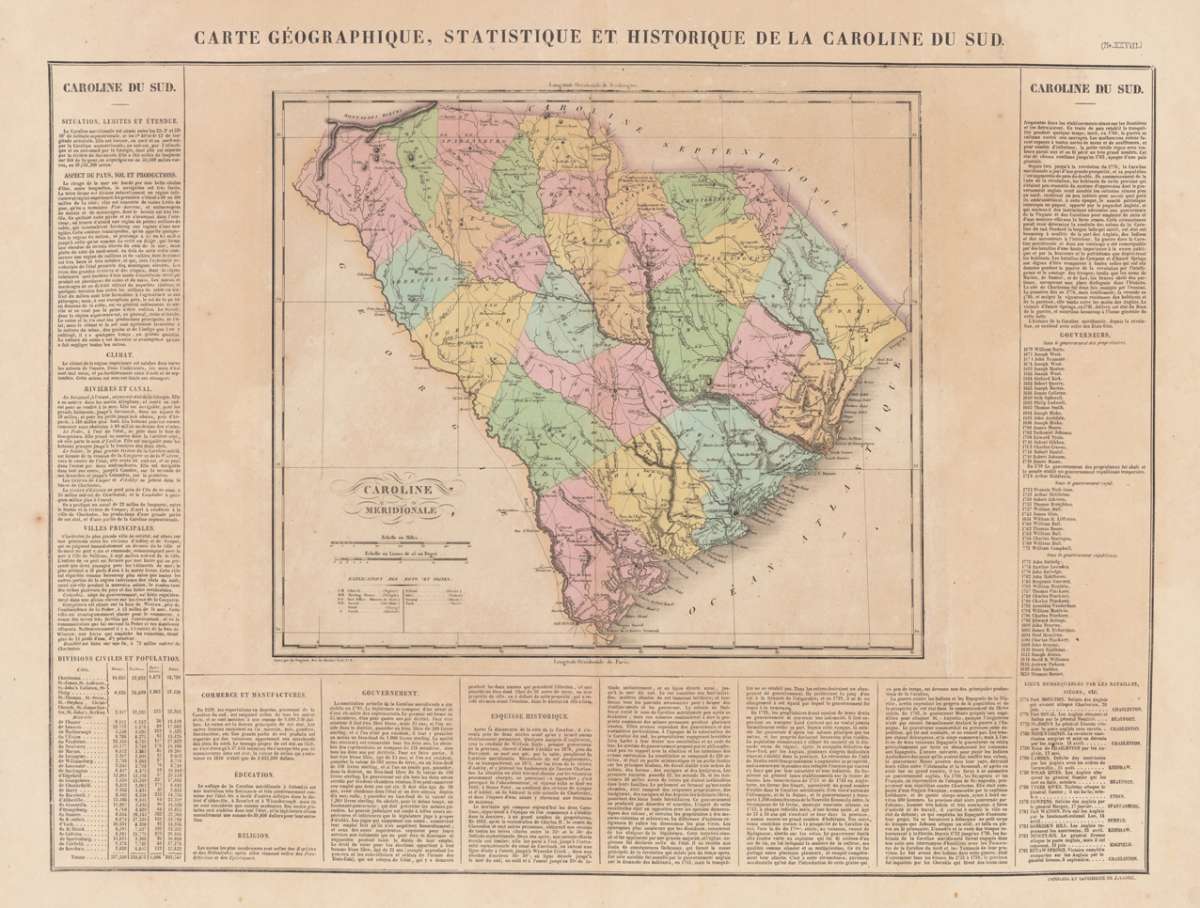
Buchon, Jean Alexandre – Caroline Meridionale. Carte Géographique, Statistique e... · Antique Map, Copper Engraving · 440 x 610mm · Carez, Paris 1825
Eigenschaften
- Published: Carez , Paris
- Published date: 1825
- Technique: Copper engraving / Original color.
- Type: Antique Map, map
- Issue date: 1825
- Category: South Carolina
- Size: 440 by 610mm (17 by 24 inches).
- Stock number: 14017
- Condition: In excellent condition. 440 by 610mm (17 by 24 inches).
Article description
Article description
Copper Engraving, hand-colored in outline by Buchon, Jean Alexandre, published 1825 by Carez, Paris. Image size: 440 by 610mm (17 by 24 inches). A detailed map from Buchon's 1825 Atlas géographique, the French edition of Carey & Lea's celebrated American atlas. Jean Alexandre Buchon (1791–1846) was a French historian and geographer who produced the influential Atlas géographique, statistique, historique et chronologique des deux Amériques et des îles adjacentes (1825), published in Paris by J. Carez. This atlas was the French edition of the celebrated Carey & Lea atlas of the United States. Each map was surrounded by letterpress text describing the economic, political, geographical, and historical statistics of the depicted region in French, making it an extraordinary reference work for European readers at the dawn of the Americas' independence era. The maps were engraved in Paris to the highest standards of the day and remain important primary documents for the study of early 19th-century American geography as understood by European scholars. French edition of the 1822 in Philadelphia published map by Carey & Lea. The map was engraved by B. de Beaupre. In excellent condition.Buchon, Jean Alexandre – Caroline Meridionale. Carte Géographique, Statistique e... · Antique Map, Copper Engraving · 440 x 610mm · Carez, Paris 1825
You might also be interested in the following products
 Süd Carolina....
 Copper Engraving, uncolored by Drayton, J, published 1806 by Geographisches Institut, Weimar. Image size: 214 by...
€245.00
 Neueste Karte von...
 Steel Engraving, hand-colored in outline by Meyer, Joseph, published 1852 by Meyers, Hildburghausen. Image size: 300...
€205.00
 Carolina By...
 Copper Engraving, uncolored by Moll, Herman, published 1736 by Th. Bowles and John Bowles, London. Image size: 176 by...
€545.00
Recently viewed products