Bromley, George W. & Walter S.
Part of Sections 3 New York City (Scale 200 feet to Inch)
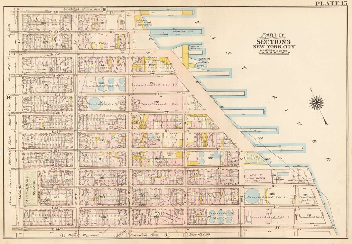
Bromley, George W. & Walter S. – Part of Sections 3 New York City (Scale 200 feet to Inc... · Antique Map, Lithograph · 51.5 x 77 cm · G.W. Bromley and Compa...
Eigenschaften
- Published: USA
- Published date: 1916
- Category: New York
- Technique: Lithograph / Original color
- Type: map
- Issue date: 1916
- Size: 51.5 x 77 cm (20.25 x 30,25 inches).
- Bibliography: Plate 15
- Stock number: 35947
- Condition: Outside of the image 2 defects on the edge (disappear under the passe-partout).
Article description
Article description
Lithograph by Bromley, George W. & Walter S, published 1916 by G.W. Bromley and Company, USA. Image size: 51.5 x 77 cm (20.25 x 30,25 inches). From Bromley's New York City atlas — an invaluable primary document of the city's urban development. George W. and Walter S. Bromley were a Philadelphia-based firm of real estate atlas publishers active in the late 19th and early 20th centuries. Their large-format cadastral atlases of New York City and other major American cities are extraordinary primary documents of urban development, recording property boundaries, building footprints, and land use block by block. The Bromley New York City atlas sheets of 1916 represent the city at the height of its pre-World War I growth and are invaluable historical records sought by architectural historians, genealogists, and collectors of urban history. The map was created by G.W. Bromley and Company and is taken from the 1916 "Land Book" of New York, also known as the Atlas of the Borough of Manhattan, Desk and Library Edition. Antique map of the outline and Index Map of New York City Borough of Manhattan. This map shows the streets from 25th to 14th, with the East River on the right. The cartouche and the compas rose is also on the right side in the river. G.W. Bromley created detailed maps of New York City from 1879 through the 1950s. The hand colored lithographic maps from this volume show the development of the city in 1916, showing the city park, bridges and Dietraum. Important or larger buildings are named. Outside of the image 2 defects on the edge (disappear under the passe-partout).Bromley, George W. & Walter S. – Part of Sections 3 New York City (Scale 200 feet to Inc... · Antique Map, Lithograph · 51.5 x 77 cm · G.W. Bromley and Compa...
Plate 15
You might also be interested in the following products
 New York. Carte...
 Copper Engraving, hand-colored in outline by Buchon, Jean Alexandre, published 1825 by J. Carez, Paris. Image size:...
€250.00
 Johnson's New...
 Lithograph, original color in outline by Johnson & Ward, published 1865 by Johnson & Ward, New York. Image...
€50.00
 Geographisch-stat...
 Copper Engraving, hand-colored in outline by [Geographisches Institut], published 1824 by Geographisches Institut,...
€295.00
 Old Dutch Church...
 Lithograph by Beers, F.W, published 1868 by New York. Image size: 300 by 310mm (11 by 12 inches). From Beers's...
€155.00
Recently viewed products